Naguabo
Municipio Autónomo de Naguabo | |
|---|---|
Town and Municipality | |
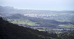
 View of Naguabo from El Yunque | |
| Nicknames: "Cuna de Grandes Artistas", "Los Enchumbaos" | |
| Anthem: "Mi Naguabo del querer, Mi Naguabo del soñar" | |
 Map of Puerto Rico highlighting Naguabo Municipality | |
| Coordinates: 18°13′10″N 65°44′12″W / 18.21944°N 65.73667°W | |
| Sovereign state | |
| Commonwealth | |
| Founded | July 15, 1821 |
| Barrios | |
| Government | |
| • Mayor | Miraidaliz Rosario Pagán (PPD) |
| • Senatorial dist. | 7 - Humacao |
| • Representative dist. | 35 |
| Area | |
| • Total | 60.1 sq mi (155.57 km2) |
| • Land | 52.1 sq mi (135 km2) |
| • Water | 7.9 sq mi (20.57 km2) |
| Population (2020) | |
| • Total | 23,386 |
| • Rank | 52nd in Puerto Rico |
| • Density | 390/sq mi (150/km2) |
| Demonym | Naguabeños |
| Time zone | UTC−4 (AST) |
| ZIP Codes | 00718, 00744 |
| Area code | 787/939 |
| Major routes | |
Naguabo (Spanish pronunciation: [naˈɣwaβo], locally [naˈwaβo]) is a town and municipality in Puerto Rico located in the east coast of the island bordered by the Vieques Passage, north of Humacao; south of Río Grande and Ceiba; and east of Las Piedras. Naguabo is spread over 8 barrios and Naguabo Pueblo (the downtown area and the administrative center of the city). It is part of the San Juan-Caguas-Guaynabo Metropolitan Statistical Area.
Naguabo is renowned for and is said to be the birthplace of the pastelillo de chapín, which is a popular food in Puerto Rico. It is trunkfish wrapped inside deep-fried flour dough. Pastelillos de chapín can be found in almost any seaside establishment on the island.

