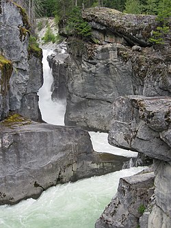
| Nairn Falls Provincial Park | |
|---|---|
 Nairn Falls | |
Location of Nairn Falls Provincial Park in British Columbia | |
| Location | British Columbia, Canada |
| Nearest city | Pemberton |
| Coordinates | 50°17′37″N 122°49′08″W / 50.29373°N 122.8189°W |
| Area | 170 hectare |
| Established | 4 April 1966 |
| Governing body | BC Parks |
| Website | bcparks |
 | |
This article relies largely or entirely on a single source. (August 2021) |
Nairn Falls Provincial Park (Ucwalmícwts (Lillooet): Skweskwistqw7am, IPA: [ʃkʷəʃkʷeʃtqʷʔɛm]) is a provincial park in British Columbia, Canada located on the Green River adjacent to British Columbia Highway 99 and the Canadian National Railway line just south of Pemberton and less than twenty minutes north of the resort town of Whistler. The 170 hectare park was established in 1966, shortly after the highway's opening, to protect and enhance visitor access to Nairn Falls.
