This article needs additional citations for verification. (October 2022) |
Nakagusuku
中城村 | |
|---|---|
Village | |
 Nakagusuku Village Office | |
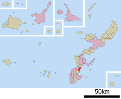
 Location of Nakagusuku in Okinawa Prefecture | |
| Coordinates: 26°16′4″N 127°47′29″E / 26.26778°N 127.79139°E | |
| Country | Japan |
| Region | Ryukyu |
| Prefecture | Okinawa Prefecture |
| District | Nakagami |
| Government | |
| • Mayor | Keisuke Hamada |
| Area | |
| • Total | 15.46 km2 (5.97 sq mi) |
| Population (October 1, 2020) | |
| • Total | 22,157 |
| • Density | 1,400/km2 (3,700/sq mi) |
| Time zone | UTC+09:00 (JST) |
| City hall address | 176 Tōma, Nakagusuku-mura, Nakagami-gun 901-2493 |
| Website | www |
| Symbols | |
| Fish | Ijukin (Threadfin bream) |
| Flower | Hibiscus |
| Tree | Ebony |
Nakagusuku (中城村, Nakagusuku-son, Okinawan: Nakagushiku) is a village located in Nakagami District, Okinawa Prefecture, Japan. As of 1 October 2020, the village has an estimated population of 22,157 and a density of 1,400 persons per km2. The total area is 15.46 km2. The ruins of a gusuku (Ryukyuan castle), Nakagusuku Castle, are also in this village. It is famous for its ancient Chinese dance, Tafaku, which has been handed down for generations. The village is well known among Okinawans as an agricultural farming village, with its staple crop being sugar cane (Okinawan: wuuji. Japanese: satokibi). It is also known for its white or yellow colored carrots. Ryukyu University is partially located within Nakagusuku, and partially in the neighboring town of Nishihara. Nakagusuku features one of the largest percentages of people of Okinawan descent who immigrated overseas out of all the districts in Okinawa.

