| Nan River | |
|---|---|
 Nan River at Mueang Uttaradit District, Uttaradit Province | |
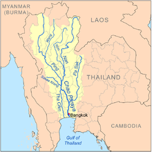
 Map of the Chao Phraya River drainage basin showing the Nan River | |
| Location | |
| Country | Thailand |
| Cities | Nan, Uttaradit, Phitsanulok, Phichit, Nakhon Sawan |
| Physical characteristics | |
| Source | Luang Prabang Range |
| • location | Bo Kluea District, Nan Province |
| • coordinates | 19°20′0″N 101°12′0″E / 19.33333°N 101.20000°E |
| • elevation | 1,240 m (4,070 ft) |
| Mouth | Chao Phraya |
• location | Pak Nam Pho, Nakhon Sawan |
• coordinates | 15°42′04″N 100°08′31″E / 15.701°N 100.142°E |
• elevation | 25 m (82 ft) |
| Length | 740 km (460 mi)[1] |
| Basin size | 57,947 km2 (22,373 sq mi) |
| Discharge | |
| • location | Nakhon Sawan[2] |
| • average | 472 m3/s (16,700 cu ft/s) |
| • maximum | 1,522 m3/s (53,700 cu ft/s) |
| Basin features | |
| Tributaries | |
| • left | Lam Wa, Nam Pat, Khwae Noi River, Wang Thong River |
| • right | Yom River |
The Nan River (Thai: แม่น้ำน่าน, RTGS: Maenam Nan, pronounced [mɛ̂ː.náːm nâːn]; Northern Thai: น้ำแม่น่าน, pronounced [náːm mɛ̂ː.nâːn]) is a river in Thailand. It is one of the most important tributaries of the Chao Phraya River.

- ^ "Longest Rivers in Thailand". 25 April 2017.
- ^ Discharge locations [dead link]