| Nankoweap Formation | |
|---|---|
| Stratigraphic range: Neoproterozoic, <770 Ma | |
 | |
| Type | Geological formation |
| Unit of | Grand Canyon Supergroup |
| Underlies | Chuar Group and, as part of the Great Unconformity, the Tapeats Sandstone |
| Overlies | Cardenas Basalt |
| Thickness | 110 m (360 ft) approximate maximum |
| Lithology | |
| Primary | sandstone, siltstone & shale (red beds) |
| Location | |
| Region | Arizona east Grand Canyon Lava Butte region on Colorado River, near Lipan Point |
| Country | United States (Southwestern United States) |
| Extent | (eastern) Grand Canyon, Colorado River region |
| Type section | |
| Named for | Nankoweap Canyon |
| Named by | Van Gundy (1934),[3] Van Gundy (1951),[4] and Maxson (1961)[5] |
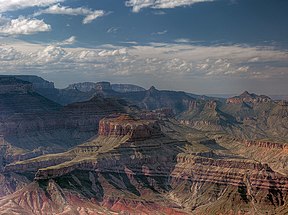
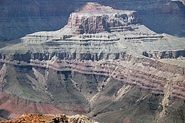
The Neoproterozoic Nankoweap Formation (pronounced Nan' coe weep), is a thin sequence of distinctive red beds that consist of reddish brown and tan sandstones and subordinate siltstones and mudrocks that unconformably overlie basaltic lava flows of the Cardenas Basalt of the Unkar Group and underlie the sedimentary strata of the Galeros Formation of the Chuar Group. The Nankoweap Formation is slightly more than 100 m in thickness. It is informally subdivided into informal lower and upper members that are separated and enclosed by unconformities. Its lower (ferruginous) member is 0 to 15 m thick. The Grand Canyon Supergroup, of which the Nankoweap Formation is part, unconformably overlies deeply eroded granites, gneisses, pegmatites, and schists that comprise Vishnu Basement Rocks.[6][7][8]
The strata of the Nankoweap Formation are exposed in a small area that occupies an area from just south of Carbon Canyon to Basalt Canyon on the west bank of the Colorado River around Comanche Creek and Tanner Canyon on the east bank of the Colorado River within the eastern Grand Canyon, Coconino County, Arizona. It and associated strata of the Unkar and Chuar Groups are preserved in a prominent syncline and fault block. The most complete, readily accessible, and easily studied, exposure of the Nankoweap Formation occurs in Basalt Canyon.[6][7]
The nomenclature of the Nankoweap Formation has changed over time. Originally, the strata of the Nankoweap Formation was included in-part in the top of the "Unkar terrane" (Group) and in-part in the basal “Chuar terrane” (Group) by Walcott in 1894.[9] Van Gundy first recognized the thin sequence of red beds unconformably overlying basaltic flows of the Unkar Group as a separate stratigraphic unit, which he called the “Nankoweap Group.“[3]

Although more extensive outcrops exist in Basalt Canyon, Comanche Creek, and Tanner Canyon, it is named for a small, fault-bounded block of the Nankoweap Formation in Nankoweap Canyon. It was argued that these redbeds belonged neither to the underlying Unkar Group nor overlying Chuar Group.[4] Maxson in his geological mapping reduced the Nankoweap Group to formational rank because the Nankoweap had not been subdivided into formations.[5] Later, a locally preserved lower member (ferruginous unit and weathered zone) that unconformably overlies the Cardenas Basalt and is unconformably overlain by the upper member of the Nankoweap – was recognized.[6][7]
- ^ Blakey, R, and W Ranney (2008) Ancient Landscapes of the Colorado Plateau. Grand Canyon Association, Grand Canyon, Arizona. 176 pp, ISBN 978-1934656037
- ^ DeLorme Mapping Company (2002) Arizona atlas & gazetteer : detailed topographic maps, back roads, BLM, state lands, GPS grids, 5th ed. DeLorme Mapping Company, Yarmouth, Maine.
- ^ a b Van Gundy, C.E. (1934) Some observations of the Unkar Group of the Grand Canyon Algonkian. Grand Canyon Nature Notes. 9(8):338–349.
- ^ a b Van Gundy, CE (1951) Nankoweap group of the Grand Canyon Algonkian of Arizona. Geological Society of America Bulletin 62(8):953–959.
- ^ a b Maxson J.H. (1961) Geologic history of the Bright Angel quadrangle. in J.H. Maxson and F. Matthes, compilers, Geologic map of the Bright Angel quadrangle. Canyon Natural History Association, Grand Canyon, Arizona.
- ^ a b c Elston, DP (1989) Middle and late Proterozoic Grand Canyon Supergroup, Arizona. In DP Elston, GH Billingsley, and RA Young, RA., eds., pp. 94–105, Geology of the Grand Canyon, Northern Arizona (with Colorado River Guides). American Geophysical Union Fieldtrip Guidebook T115/315 for International Geologic Congress, 28th. American Geophysical Union, Washington DC. 239 pp.
- ^ a b c Ford, TD, and CM Dehler (2003) Grand Canyon Supergroup; Nankoweap Formation, Chuar Group, and Sixtymile Formation. Grand Canyon geology. In SS Beus and M Morales, eds., pp. 53–75, Grand Canyon Geology, 2nd ed. Oxford University Press, New York. ISBN 0195122984
- ^ Timmons, JM, KE Karlstrom, MT Heizler, SA Bowring, GE Gehrels, and LJ Crossey, (2005) Tectonic inferences from the ca. 1254–1100 Ma Unkar Group and Nankoweap Formation, Grand Canyon: Intracratonic deformation and basin formation during protracted Grenville orogenesis. Geological Society of America Bulletin. 117(11–12):1573–1595.
- ^ Walcott, CD (1894) Precambrian igneous rocks of the Unkar terrane, Grand Canyon of the Colorado. 14th Annual Report for 1892/3, part 2, pp. 492–519, United States Geological Survey, Reston, Virginia.