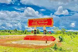
Namsang
ဝဵင်းၼမ်ႉၸၢင် နမ့်စန်မြို့ | |
|---|---|
Town | |
 Sign at entrance of Namsang | |
| Coordinates: 20°53′20″N 97°44′10″E / 20.88889°N 97.73611°E | |
| Country | |
| State | |
| District | Namsang District |
| Township | Namsang Township |
| Area | |
| • Total | 1,594.62 sq mi (4,130.0 km2) |
| Elevation | 3,255 ft (992 m) |
| Population | |
| • Total | 26,060 |
| • Density | 16/sq mi (6.3/km2) |
| Time zone | UTC+6.30 (MMT) |
| Area code | 06161 |
Nansang (Burmese: ဝဵင်းၼမ်ႉၸၢင်) or Namsang is a town in Namsang District of Shan State in eastern Myanmar. It is the seat of Nansang Township. It is the biggest settlement of the eastern central area of the Shan State in Myanmar with 26,060 people in 2019. Most residents live in Ward 4, the northwest part of the town.[2] It is 72 miles away from Taunggyi. A pagoda lies in the southern part of the town. It is also known as Taung Paw Pagoda.
- ^ GoogleEarth
- ^ a b Myanmar Information Management Unit (September 2019). Nansan Myone Daethasaingyarachatlatmya နမ့်စန်မြို့နယ် ဒေသဆိုင်ရာအချက်လက်များ [Nansang Township Regional Information] (PDF) (Report). MIMU. Retrieved 6 August 2024.
