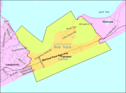
Napeague, New York | |
|---|---|
 Mackay Tower and Art Barge | |
 | |
| Coordinates: 40°59′42″N 72°4′30″W / 40.99500°N 72.07500°W | |
| Country | United States |
| State | New York |
| County | Suffolk |
| Town | East Hampton |
| Area | |
| • Total | 8.54 sq mi (22.13 km2) |
| • Land | 3.68 sq mi (9.53 km2) |
| • Water | 4.87 sq mi (12.60 km2) |
| Elevation | 7 ft (2 m) |
| Population (2020) | |
| • Total | 368 |
| • Density | 100.00/sq mi (38.61/km2) |
| Time zone | UTC-5 (Eastern (EST)) |
| • Summer (DST) | UTC-4 (EDT) |
| FIPS code | 36-49424 |
| GNIS feature ID | 0958252 |

Napeague (/ˈnæpiːɡ/, NAP-eeg) is a census-designated place (CDP) that roughly corresponds to the hamlet with the same name in the Town of East Hampton in Suffolk County, New York, United States. The CDP population was 200 at the 2010 census.[2]
Napeague is located on a very narrow, low-lying strip between the Atlantic Ocean to the south and Gardiners Bay to the north that was flooded in the Great Hurricane of 1938. It lies between Napeague State Park on the west and Hither Hills State Park on the east.
Napeague derives its name from the Montaukett name for "land overflowed by the sea".[3]
- ^ "ArcGIS REST Services Directory". United States Census Bureau. Retrieved September 20, 2022.
- ^ "Geographic Identifiers: 2010 Demographic Profile Data (G001): Napeague CDP, New York". U.S. Census Bureau, American Factfinder. Archived from the original on February 12, 2020. Retrieved January 4, 2013.
- ^ "The Sag Harbor Express". Archived from the original on August 8, 2007. Retrieved June 10, 2007.


