This article needs additional citations for verification. (May 2019) |
Naraingarh
Narayangarh | |
|---|---|
Town | |
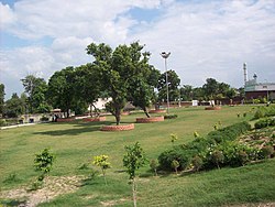
 Mc-park-naraingarh | |
| Coordinates: 30°28′35″N 77°07′40″E / 30.47639°N 77.12778°E | |
| Country | |
| State | Haryana |
| District | Ambala |
| Founded by | Raja Lakshmi Narain King of Sirmaur |
| Named for | Raja Lakshmi Narain of Sirmaur State |
| Government | |
| • Body | Municipal Corporation |
| Area | |
• Total | 481 km2 (186 sq mi) |
| Population (2011)[1] | 28,832 |
| Demonym | Naraiangarhiye |
| Languages[2][3] | |
| • Official | Hindi |
| • Additional official | English, Punjabi |
| • Regional | Haryanvi[4] |
| Time zone | UTC+5:30 (IST) |
| PIN | 134203 |
| Telephone code | 91 1734 |
| ISO 3166 code | IN-HR |
| Vehicle registration | HR-04 |
| Sex ratio | 890 |
| Website | haryana |
Naraingarh (also: Narayangarh) is a town, municipal committee and assembly constituency in the Ambala district of the Indian state of Haryana, located on the border with the Indian state of Himachal Pradesh. Due to its geographical location, the Naraingarh plays an important role in local tourism, being located 39 km from Ambala, the district headquarter, 52 km (32 miles) of Chandigarh, the state capital, 144 km (89 miles) of Shimla, and 230 km (142 miles) of New Delhi.
- ^ Cite error: The named reference
Census2011Govwas invoked but never defined (see the help page). - ^ "Report of the Commissioner for linguistic minorities: 52nd report (July 2014 to June 2015)" (PDF). Commissioner for Linguistic Minorities, Ministry of Minority Affairs, Government of India. pp. 85–86. Archived from the original (PDF) on 15 November 2016. Retrieved 24 March 2019.
- ^ IANS (28 January 2010). "Haryana grants second language status to Punjabi". Hindustan Times. Retrieved 24 March 2019.
- ^ "Haryanvi". Ethnologue. Retrieved 8 February 2020.

