| Narawntapu National Park Tasmania | |
|---|---|
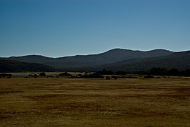
 Narawntapu National Park, December 2009 | |
 | |
| Nearest town or city | Port Sorell |
| Coordinates | 41°07′58″S 146°39′24″E / 41.13278°S 146.65667°E |
| Established | 1976 |
| Area | 43.49 km2 (16.8 sq mi) |
| Visitation | 10,100 (in 1996/97)[1] |
| Managing authorities | Tasmania Parks and Wildlife Service |
| Website | Narawntapu National Park |
| See also | Protected areas of Tasmania |
Narawntapu National Park (formerly known as Asbestos Range National Park) is a national park in the Australian state of Tasmania. It lies on Tasmania's north coast, adjoining Bass Strait, between Port Sorell in the west and the mouth of the Tamar River in the east. It lies about 20 km east of Devonport, 60 km north-west of Launceston and 250 km north of Hobart.
Narawntapu encompasses islands in the Port Sorell estuary and the Carbuncle, as well as land extending to low water mark, including intertidal mudflats. The highest point of the park is 392 m ASL. It is listed on Australia's Register of the National Estate.[1]
Narawntapu is popular with visitors, with many coming from the tourist centres of Devonport and Port Sorell. The visitor centre is located in an area known as Springlawn, where visitors can see Forester kangaroos, Bennett's wallabies, Tasmanian pademelons grazing in the open plain.[2]
- ^ a b Anon. (2000). Narawntapu National Park, Hawley Nature Reserve - Management Plan 2000. Parks and Wildlife Service, Tasmania. ISBN 0-7246-2122-9 "Archived copy" (PDF). Archived from the original (PDF) on 22 July 2008. Retrieved 21 July 2008.
{{cite web}}: CS1 maint: archived copy as title (link) PDF download - ^ "Narawntapu National Park". Parks Tasmania. Retrieved 18 January 2021.