Narayanganj
নারায়ণগঞ্জ | |
|---|---|
|
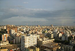
From top: City Skyline, Port of Narayanganj, Tomb of Sultan Ghiyasuddin Azam Shah , Baro-Bhuyan Palace of Lord Isa Khan, Historical Panam City, Hajiganj Fort in City East | |
| Coordinates: 23°37′12″N 90°30′00″E / 23.62000°N 90.50000°E | |
| Country | |
| Division | Dhaka |
| District | Narayanganj |
| Municipal Board | 8 September 1876 |
| Metropolitan city | 5 May 2011 |
| Government | |
| • Type | Mayor–council government |
| • Body | Narayanganj City Corporation |
| • Administrator | A. H. M. Kamruzzaman |
| Area | |
| 33.57 km2 (12.96 sq mi) | |
| • Water | 48.56 km2 (18.75 sq mi) |
| • Metro | 72.43 km2 (27.97 sq mi) |
| Elevation | 3 m (10 ft) |
| Population | |
| 967,951 | |
| • Density | 29,000/km2 (75,000/sq mi) |
| Time zone | UTC+6 (Bangladesh Time) |
| Postal code | 1420 |
| Area code | 0671 |
| Calling Code | 02 |
| Website | ncc |
Narayanganj (Bengali: নারায়ণগঞ্জ, romanized: Narayongônjo) is a city in central Bangladesh in the Greater Dhaka area. It is in the Narayanganj District, about 16 km (10 mi) southeast of the capital city of Dhaka. With a population of almost 1 million, it is the 6th largest city in Bangladesh.[2] It is also a center of business and industry, especially the jute trade and processing plants, and the textile sector of the country. It is nicknamed the Dundee of Bangladesh, due to the presence of its many jute mills. (Dundee was the first industrialised 'Juteopolis' in the world.[3])
- ^ Cite error: The named reference
2022censuswas invoked but never defined (see the help page). - ^ Solaiman, Md. (2012). "Narayanganj". In Sirajul Islam; Miah, Sajahan; Khanam, Mahfuza; Ahmed, Sabbir (eds.). Banglapedia: the National Encyclopedia of Bangladesh (Online ed.). Dhaka, Bangladesh: Banglapedia Trust, Asiatic Society of Bangladesh. ISBN 984-32-0576-6. OCLC 52727562. OL 30677644M. Retrieved 28 November 2024.
- ^ "Jute Industry in Dundee and India". Dundee (UK). Archived from the original on 2017-04-15. Retrieved 2017-12-20.


