| Narooma New South Wales | |||||||||||||||
|---|---|---|---|---|---|---|---|---|---|---|---|---|---|---|---|
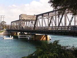
 Bridge at Narooma on the Princes Highway | |||||||||||||||
| Coordinates | 36°12′S 150°08′E / 36.200°S 150.133°E | ||||||||||||||
| Population | 3,342 (2016 census)[1] | ||||||||||||||
| Established | 1881 | ||||||||||||||
| Postcode(s) | 2546 | ||||||||||||||
| Elevation | 30 m (98 ft) | ||||||||||||||
| Location | |||||||||||||||
| LGA(s) | Eurobodalla Shire | ||||||||||||||
| County | Dampier | ||||||||||||||
| State electorate(s) | Bega | ||||||||||||||
| Federal division(s) | Eden-Monaro | ||||||||||||||
| |||||||||||||||
Narooma is a town in the Australian state of New South Wales on the far south coast. The town is on the Princes Highway, which crosses the Wagonga Inlet to North Narooma. The heritage town of Central Tilba is nearby to the south.
The name Narooma is said to be derived from a word in the local Aboriginal language (one of the Yuin dialects) meaning "clear blue waters".
At the 2016 census, Narooma had an urban population of over 3,000 people.
- ^ Australian Bureau of Statistics (27 June 2017). "Narooma (Urban Centre)". 2016 Census QuickStats. Retrieved 3 December 2017.
- ^ "www.lovenarooma.com". Driving distances. Elise International Research. 2015. Archived from the original on 18 May 2015. Retrieved 10 May 2015.
