| Narragansett Bay | |
|---|---|
 | |
| Location | Rhode Island, Massachusetts, United States |
| Coordinates | 41°36′N 71°21′W / 41.600°N 71.350°W |
| Type | Bay |
| Surface area | 147 square miles (380 km2) |
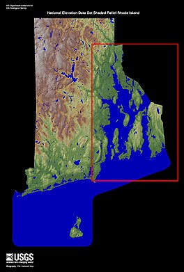
Narragansett Bay is a bay and estuary on the north side of Rhode Island Sound covering 147 square miles (380 km2), 120.5 square miles (312 km2) of which is in Rhode Island.[1] The bay forms New England's largest estuary, which functions as an expansive natural harbor and includes a small archipelago.[2] Small parts of the bay extend into Massachusetts.
There are more than 30 islands in the bay; the three largest ones are Aquidneck Island, Conanicut Island, and Prudence Island.[3] Bodies of water that are part of Narragansett Bay include the Sakonnet River, Mount Hope Bay, and the southern, tidal part of the Taunton River. The bay opens on Rhode Island Sound and the Atlantic Ocean; Block Island lies less than 20 miles (32 km) southwest of its opening.
- ^ 1998 Journal-Bulletin Rhode Island Almanac, 112th Annual Edition, p. 36.
- ^ Keller, Aimee A.; Klein-MacPhee, Grace; Burns, Jeanne St. Onge (January 1, 1999). "Abundance and Distribution of Ichthyoplankton in Narragansett Bay, Rhode Island, 1989–1990". Estuaries. 22 (1): 149–163. doi:10.2307/1352935. JSTOR 1352935. S2CID 84501320.
- ^ "The Islands – City of Providence Website". Providenceri.com. Archived from the original on April 10, 2010. Retrieved April 3, 2010.
