| Narrandera New South Wales | |||||||||
|---|---|---|---|---|---|---|---|---|---|
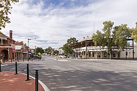
 East Street, main street of Narrandera | |||||||||
| Coordinates | 34°45′0″S 146°33′0″E / 34.75000°S 146.55000°E | ||||||||
| Population | 4,369 (2021 census)[1] | ||||||||
| Postcode(s) | 2700[2] | ||||||||
| Elevation | 173.0 m (568 ft) | ||||||||
| Location |
| ||||||||
| LGA(s) | Narrandera Shire | ||||||||
| County | Cooper | ||||||||
| State electorate(s) | Cootamundra | ||||||||
| Federal division(s) | Farrer | ||||||||
| |||||||||
Narrandera, (/nəˈrændərə/ nə-RAN-dər-ə)[3] until around 1949 also spelled "Narandera",[4] is a town located in the Riverina region of south-western New South Wales, Australia. The town lies on the junction of the Newell and Sturt highways, adjacent to the Murrumbidgee River, and it is considered the gateway to the Murrumbidgee Irrigation Area. At the 2016 census, Narrandera had a population of 3746 people.[5]
- ^ Australian Bureau of Statistics (28 June 2022). "Narrandera (Suburbs and Localities)". 2021 Census QuickStats. Retrieved 24 November 2024.
- ^ Narrandera Postcode Australia Post
- ^ Macquarie Dictionary, Fourth Edition (2005). Melbourne, The Macquarie Library Pty Ltd. ISBN 1-876429-14-3
- ^ "Correspondence". Narandera Argus and Riverina Advertiser (NSW : 1893 - 1953). NSW: National Library of Australia. 26 June 1945. p. 2. Retrieved 16 December 2013.
- ^ Australian Bureau of Statistics (27 June 2017). "Narrandera (Urban Centre/Locality)". 2016 Census QuickStats. Retrieved 1 December 2017.
