Nathoka Gali
نتھوکا گلی | |
|---|---|
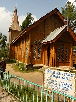
 Nathia Gali's St. Matthew's Church, which was built during British colonial rule, photographed in 2014 | |
| Coordinates: 34°04′N 73°23′E / 34.067°N 73.383°E | |
| Country | |
| Province | |
| District | Abbottabad District |
| Tehsil | Abbottabad Tehsil |
| Government | |
| • Nazim | Sardar Fayyaz Khan Dahir[1] |
| • Naib Nazim | Sardar Zaheed |
| • V.C. Naib Nazim | Wali Ur Rehman Khan |
| Elevation | 2,410 m (7,910 ft) |
| Time zone | UTC+5:00 (Pakistan Standard Time) |


Nathia Gali or Nathiagali (Urdu: نتھیا گلی) is a hill station and mountain resort town located in the Abbottabad District of Khyber Pakhtunkhwa, Pakistan. It is located at the centre of the Galyat range, where several hill stations are situated. Nathia Gali is known for its scenery, hiking trails and weather,[citation needed] which is much cooler than the rest of the Galyat range due to it being at a higher altitude. It is situated approximately 32 kilometres (20 mi) away from both Murree and Abbottabad.[2][3]
- ^ Cite error: The named reference
AbbGovwas invoked but never defined (see the help page). - ^ Nathia Gali - Imperial Gazetteer of India, v. 18, p. 415
- ^ Nathiagali Archived 2012-08-28 at the Wayback Machine, Publisher: Tourism Development Corporation of Punjab (TDCP). Retrieved 27 October 2012

