| National Highway 10 | ||||
|---|---|---|---|---|
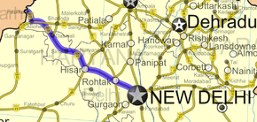
 Road map of India with National Highway 10 highlighted in solid blue color | ||||
| Route information | ||||
| Length | 403 km (250 mi) | |||
| Major junctions | ||||
| East end | Delhi | |||
| West end | Fazilka | |||
| Location | ||||
| Country | India | |||
| States | Delhi: 18 km Haryana: 313 km Punjab: 72 km | |||
| Primary destinations | Delhi - Rohtak - Hisar - Sirsa - Fazilka | |||
| Highway system | ||||
| ||||
National Highway 10 was a National Highway, length 403 km (250 mi),[1] in North India that originated at Delhi and ended at the town of Fazilka in Punjab near the Indo-Pak Border.
- ^ "Archived copy". Archived from the original on 10 April 2009. Retrieved 20 July 2011.
{{cite web}}: CS1 maint: archived copy as title (link)

