| National Highway 76 | ||||
|---|---|---|---|---|
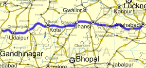
 Road map of India with National Highway 76 highlighted in solid red color | ||||
| Route information | ||||
| Length | 1,007 km (626 mi) | |||
| Major junctions | ||||
| West end | Pindwara, Rajasthan | |||
| Jhansi, Harpalpur, Panwari, Kulpahar, Mahoba, Kabrai and Banda | ||||
| East end | NH 27 south of Allahabad | |||
| Location | ||||
| Country | India | |||
| States | Rajasthan: 480 km (300 mi) Madhya Pradesh: 60 km (37 mi) Uttar Pradesh: 467 km (290 mi) | |||
| Primary destinations | Pindwara - Udaipur - Chittaurgarh - Kota - Shivpuri - KARERA - Jhansi - Banda - Allahabad | |||
| Highway system | ||||
| ||||
National Highway 76 or NH 76 is a National Highway in India that links Allahabad in Uttar Pradesh with Pindwara in Rajasthan. This 1,007-kilometre-long (626 mi) highway passes through Udaipur, Kota, Shivpuri, Jhansi and Banda.
Of its total length, the National Highway 76 traverses 467 km (290 mi)in Uttar Pradesh, 60 km (37 mi) Madhya Pradesh and 480 km (300 mi) in Rajasthan.
