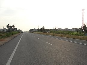
| National Highway 79 | ||||
|---|---|---|---|---|
Map of the National Highway in red | ||||
 | ||||
| Route information | ||||
| Part of | ||||
| Length | 134.2 km (83.4 mi) | |||
| Major junctions | ||||
| West end | Salem, Tamil Nadu | |||
| East end | Ulundurpettai, Villupuram district, Tamil Nadu | |||
| Location | ||||
| Country | India | |||
| States | Tamil Nadu | |||
| Primary destinations | Ulundrupet - Kallakurichi - Chinnasalem - Attur - Pethanaickenpalayam - Vazhapadi - Salem | |||
| Highway system | ||||
| ||||
National Highway 79 (NH 79) is a National Highway in India entirely within the state of Tamil Nadu.[1] It runs between Ulundurpettai and Salem in the Indian state of Tamil Nadu for a total of 134 km (83 mi).[2] It connects with NH 44 and NH 544 at Salem. NH 79 connects NH 68 and SH 69 at Ulundurpettai and SH 6 at kallakurichi. It was upgraded to a dual carriageway road in two phases on a Build-operate-transfer basis by Reliance Infrastructure and Maytas.[3]
- ^ "New Numbering of National Highways notification - Government of India" (PDF). The Gazette of India. Retrieved 13 April 2019.
- ^ "National Highways Starting and Terminal Stations". Ministry of Road Transport & Highways. Retrieved 2 December 2012.
- ^ R, Ilangovan (19 March 2009). "Satyam fiasco affects NH-79works". The Hindu. Salem. Archived from the original on 19 November 2009. Retrieved 13 May 2012.

