Natural Bridge Station, Virginia (Greenlee) | |
|---|---|
Unincorporated community | |
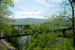
 The James River is framed by crossing railway lines at Natural Bridge Station. | |
| Coordinates: 37°37′15″N 79°30′21″W / 37.62083°N 79.50583°W | |
| Country | United States |
| State | Virginia |
| County | Rockbridge |
| Rockbridge Board of Supervisors Current Term | January 1, 2020 - December 31, 2023 |
| Government | |
| • Type | County District (Natural Bridge, Rockbridge County) |
| • District Supervisor | David B. McDaniel |
| Area | |
| • Total | 33.1 sq mi (86 km2) |
| • Land | 32.7 sq mi (85 km2) |
| • Water | 0.4 sq mi (1 km2) |
| Elevation | 764 ft (233 m) |
| Population (2020) | |
| • Total | 1,540 |
| • Density | 47/sq mi (18/km2) |
| Time zone | UTC-5 (Eastern (EST)) |
| • Summer (DST) | UTC-4 (EDT) |
| ZIP code | 24579 |
| Area code | 540 |
| GNIS feature ID | 1493338[1] |
Natural Bridge Station is an unincorporated community in Rockbridge County, Virginia, United States, named for both its proximity to Natural Bridge and formerly having a train depot along the Norfolk & Western rail line. Formerly known as Sherwood and Greenlee, the community is located along the James River and Virginia State Route 130, 3.2 miles (5.1 km) west of Glasgow.
Natural Bridge Station is made up mostly of the southeastern corner of Rockbridge County encompassing all of the community of Arnolds Valley (named for the area's first settler, Stephen Arnold) and partially covering several other communities, with its southeastern border running along the Blue Ridge Parkway. Natural Bridge Station has a post office with ZIP code 24579.[2] The population as of 2020 was 1,540.


- ^ "Natural Bridge Station". Geographic Names Information System. United States Geological Survey, United States Department of the Interior.
- ^ United States Postal Service (2012). "USPS - Look Up a ZIP Code". Retrieved February 15, 2012.

