| Scottish Gaelic name | Eilean Nèimh |
|---|---|
| Meaning of name | "Ném's island"[1] |
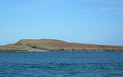
 Nave Island from Ardnave Point with the ruined chapel just visible at left | |
| Location | |
| OS grid reference | NR292759 |
| Coordinates | 55°54′N 6°20′W / 55.9°N 6.33°W |
| Physical geography | |
| Island group | Islay |
| Area | 40 ha (1⁄8 sq mi)[2] |
| Area rank | 220= [3] |
| Highest elevation | 34 m (112 ft) |
| Administration | |
| Council area | Argyll and Bute |
| Country | Scotland |
| Sovereign state | United Kingdom |
| Demographics | |
| Population | 0 |
| References | [4] |
Nave Island lies to the north of Islay in the Inner Hebrides near the mouth of Loch Gruinart.[5] It is uninhabited.
- ^ Mac an Tàilleir, Iain (2003) Ainmean-àite/Placenames. (pdf) Pàrlamaid na h-Alba. Retrieved 26 August 2012. p. 91
- ^ "Rick Livingstone’s Tables of the Islands of Scotland" (pdf) Argyll Yacht Charters. Retrieved 23 September 2013. .
- ^ Area and population ranks: there are c. 300 islands over 20 ha in extent and 93 permanently inhabited islands were listed in the 2011 census.
- ^ Ordnance Survey. OS Maps Online (Map). 1:25,000. Leisure.
- ^ "Nave Island". Gazetteer for Scotland. Retrieved 22 November 2009.
