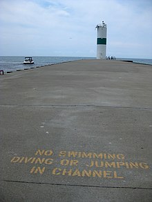
 Pentwater Pier, showing south (left) and north (right) pierhead lights | |
 | |
| Location | Pentwater, Michigan, US |
|---|---|
| Coordinates | 43°47′N 86°26′W / 43.78°N 86.44°W |
| Heritage | National Register of Historic Places listed place |
| Pentwater North Pierhead Light | |
 | |
| Constructed | 1997 |
| Foundation | concrete pier |
| Construction | cylindrical "D9-type" tower[1] |
| Height | 11 m (36 ft) |
| Fog signal | 3sec every 30sec |
| Focal height | 43 ft (13 m) |
| Lens | 12 inches (300 mm) optic |
| Range | 9 nmi (17 km; 10 mi) |
| Characteristic | Fl G 2.5s |
| Pentwater South Pierhead Light | |
 | |
| Constructed | 1937 |
| Construction | concrete (pier), steel (tower) |
| Height | 10 m (33 ft) |
| Heritage | National Register of Historic Places contributing property |
| Focal height | 48 ft (15 m) |
| Lens | 12 inches (300 mm) optic[2] |
| Range | 4 nmi (7.4 km; 4.6 mi) |
| Characteristic | Fl R 4s |
Navigation Structures at Pentwater Harbor | |
| Area | less than 1 acre (0.40 ha) |
| NRHP reference No. | 00001638[3] |
| Added to NRHP | January 11, 2001 |
| Original light | |
 | |
| Constructed | 1873 |
| Construction | lumber (artificial physical structure) |
| Automated | 1917 |
| Height | 33 ft (10 m) |
| Deactivated | 1937 |
The Navigation Structures at Pentwater Harbor are navigational structures located at the west end of Lowell Street in Pentwater, Michigan. They were listed on the National Register of Historic Places in 2001.[3]
- ^ "Pentwater Pierhead North (Lake Michigan) Light". The Weidner Publishing Group. Retrieved November 20, 2013.
- ^ "Pentwater Pierhead South (Lake Michigan) Light". The Weidner Publishing Group. Retrieved November 20, 2013.
- ^ a b "National Register Information System". National Register of Historic Places. National Park Service. July 9, 2010.