Nowlur | |
|---|---|
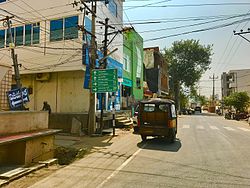
 Board showing Directions to Yerrabalem | |
| Coordinates: 16°26′37″N 80°33′28″E / 16.44361°N 80.55778°E | |
| Country | India |
| State | Andhra Pradesh |
| District | Guntur |
| Mandal | Mangalagiri |
| Area | |
| • Total | 250 km2 (100 sq mi) |
| Population | |
| • Total | 24,861 |
| • Density | 99/km2 (260/sq mi) |
| Languages | |
| • Official | Telugu |
| Time zone | UTC+5:30 (IST) |
| PIN | 522502 |
Nowlur is a neighbourhood and a part of Urban Notified Area of Amaravati, the state capital of the Indian state of Andhra Pradesh.[4] It was an out growth of Mangalagiri Municipality in Guntur district, prior to its merger in the urban area of the state capital.[5][6]
- ^ "District Census Handbook - Guntur" (PDF). Census of India. p. 14,270. Retrieved 22 February 2016.
- ^ "Census 2011". The Registrar General & Census Commissioner, India. Retrieved 22 February 2016.
- ^ "Statistical Abstract of Andhra Pradesh, 2015" (PDF). Directorate of Economics & Statistics. Government of Andhra Pradesh. p. 43. Archived from the original (PDF) on 14 July 2019. Retrieved 26 April 2019.
- ^ "New Andhra capital Amaravati to compete for Smart City tag". The New Indian Express. 25 May 2016. Archived from the original on 26 May 2016. Retrieved 6 June 2016.
- ^ "Declaration of A.P. Capital City Area–Revised orders" (PDF). Andhra Nation. Municipal Administration and Urban Development Department. 22 September 2015. Archived from the original (PDF) on 24 June 2016. Retrieved 21 February 2016.
- ^ "Name of Urban Agglomeration and its State constituent Units-2011" (PDF). Census of India. p. 11,22–23. Retrieved 21 September 2015.
