Nekoma | |
|---|---|
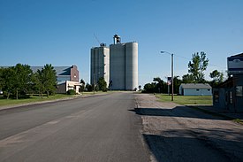
 Grain Elevator in Nekoma | |
 Location of Nekoma, North Dakota | |
| Coordinates: 48°34′35″N 98°22′16″W / 48.57639°N 98.37111°W | |
| Country | United States |
| State | North Dakota |
| County | Cavalier |
| Founded | 1905 |
| Area | |
| • Total | 0.37 sq mi (0.97 km2) |
| • Land | 0.37 sq mi (0.96 km2) |
| • Water | 0.00 sq mi (0.00 km2) |
| Elevation | 1,621 ft (494 m) |
| Population | |
| • Total | 31 |
| • Estimate (2022)[4] | 30 |
| • Density | 83.33/sq mi (32.19/km2) |
| Time zone | UTC–6 (Central (CST)) |
| • Summer (DST) | UTC–5 (CDT) |
| ZIP Code | 58355 |
| Area code | 701 |
| FIPS code | 38-55740 |
| GNIS feature ID | 1036177[2] |
Nekoma is a city in Cavalier County, North Dakota, United States. The population was 31 at the 2020 census.[3] There is a large grain elevator, a bar and two churches, plus homes at Nekoma, and an agricultural service just outside the village boundary. Nekoma was founded in 1905 and is 15 miles south of Langdon.
Of particular interest in Nekoma is the Stanley R. Mickelsen Safeguard Complex, with a large pyramid phased array radar structure visible for miles in every direction.
- ^ "2020 U.S. Gazetteer Files". United States Census Bureau. Retrieved July 24, 2022.
- ^ a b U.S. Geological Survey Geographic Names Information System: Nekoma, North Dakota
- ^ a b "Explore Census Data". United States Census Bureau. Retrieved January 17, 2024.
- ^ Cite error: The named reference
USCensusEst2022was invoked but never defined (see the help page).