Nelson
Whakatū (Māori) | |
|---|---|
City and unitary region | |
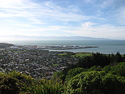
 View of Nelson from the "Centre of New Zealand" in November 2006 | |
|
| |
| Nickname(s): Top of the South, Sunny Nelson | |
| Motto(s): Latin: Palmam qui meruit ferat (Let him, who has earned it, bear the palm) | |
 Nelson region within New Zealand | |
| Coordinates: 41°16′15″S 173°17′2″E / 41.27083°S 173.28389°E | |
| Country | New Zealand |
| Island | South Island |
| Unitary authority | Nelson City |
| Settled by Europeans | 1841 |
| Founded by | Arthur Wakefield |
| Named for | Horatio Nelson |
| Electorates | Nelson Te Tai Tonga |
| Suburbs | |
| Government | |
| • Body | Nelson City Council |
| • Mayor | Nick Smith |
| • Deputy mayor | Rohan O'Neill-Stevens |
| • MPs | Rachel Boyack (Labour) Tākuta Ferris (Te Pāti Māori) |
| Area | |
• Territorial | 422.19 km2 (163.01 sq mi) |
| • Urban | 54.69 km2 (21.12 sq mi) |
| Population (June 2024)[1] | |
• Territorial | 55,200 |
| • Density | 130/km2 (340/sq mi) |
| • Urban | 51,300 |
| • Urban density | 940/km2 (2,400/sq mi) |
| Time zone | UTC+12 (NZST) |
| • Summer (DST) | UTC+13 (NZDT) |
| Postcode | 7010, 7011, 7020 |
| Area code | 03 |
| HDI (2021) | 0.927[2] very high · 7th |

Nelson (Māori: Whakatū) is a consolidated city and unitary authority on the eastern shores of Tasman Bay at the top of the South Island of New Zealand. It is the oldest city in the South Island and the second-oldest settled city in the country; it was established in 1841 and became a city by British royal charter in 1858.[3] It is the only consolidated city-region in the nation.
Nelson City is bordered to the west and south-west by the Tasman District and to the north-east, east and south-east by the Marlborough District. The Nelson urban area has a population of 51,300,[1] making it New Zealand's 15th most populous urban area.
Nelson is well known for its thriving local arts and crafts scene; each year, the city hosts events popular with locals and tourists alike, such as the Nelson Arts Festival.[4]
- ^ a b "Aotearoa Data Explorer". Statistics New Zealand. Retrieved 26 October 2024.
- ^ "Sub-national HDI – Area Database – Global Data Lab". hdi.globaldatalab.org. Archived from the original on 18 February 2023. Retrieved 18 February 2023.
- ^ "Nelson City | NZHistory, New Zealand history online". nzhistory.govt.nz. Archived from the original on 28 January 2021. Retrieved 25 January 2021.
- ^ "Nelson Arts Festival". Archived from the original on 31 March 2015. Retrieved 22 April 2015.

