| Nempnett Thrubwell | |
|---|---|
 | |
Location within Somerset | |
| Population | 177 (2011)[1] |
| OS grid reference | ST526601 |
| Unitary authority | |
| Ceremonial county | |
| Region | |
| Country | England |
| Sovereign state | United Kingdom |
| Post town | BRISTOL |
| Postcode district | BS40 |
| Dialling code | 01275 |
| Police | Avon and Somerset |
| Fire | Avon |
| Ambulance | South Western |
| UK Parliament | |
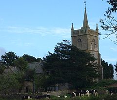
Nempnett Thrubwell is a small village and civil parish in dairying country on the western edge of Bath and North East Somerset, in the county of Somerset, England. It is about 15 km south-west of Bristol. The parish, which has a population of 177,[1] is sheltered by the Mendip Hills, near the River Yeo in the Chew Valley. It is the site of the Fairy Toot oval barrow.
Lying just to the north of Blagdon Lake, isolated Nempnett Thrubwell falls within the network of minor roads bounded by the A38, A368, B3114 and B3130; whilst signposted from each of these major routes, a lack of any further signposting makes it difficult to locate the village when arriving by road. The landscape is characterized by isolated farmsteads, the vernacular older buildings generally of the local Lias limestone or of render with clay-tiled roofs.
Though being largely rural[2] Nempnett Thrubwell's curiously comedic name makes the village something of a local attraction. It is the subject of the song Down In Nempnett Thrubwell by The Wurzels and is mentioned in the earlier Adge Cutler song Up The Clump.
- ^ a b "Nempnett Thrubwell Parish". Neighbourhood Statistics. Office for National Statistics. Retrieved 31 December 2013.
- ^ "Rural Landscapes of Bath and Northeast Somerset" (PDF). Bath and Somerset. Retrieved 16 February 2018.
