| Nether Heyford | |
|---|---|
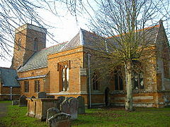
 Church of St Peter and St Paul, Nether Heyford | |
Location within Northamptonshire | |
| Population | 1,637 (2011)[1] |
| OS grid reference | SP659587 |
| Civil parish |
|
| Unitary authority | |
| Ceremonial county | |
| Region | |
| Country | England |
| Sovereign state | United Kingdom |
| Post town | NORTHAMPTON |
| Postcode district | NN7 |
| Dialling code | 01327 |
| Police | Northamptonshire |
| Fire | Northamptonshire |
| Ambulance | East Midlands |
| UK Parliament | |
Nether Heyford is a village and civil parish in West Northamptonshire, England, close to the M1 motorway and the A5 and A45 roads, 6 miles (10 km) west of Northampton and 70 miles (113 km) northwest of London. The smaller village of Upper Heyford is about half a mile to the north.
Nether Heyford takes its name from 'Hay ford'. Alternatively, 'hedge ford' or enclosure ford'.[2] In 1086, in the Domesday Book, the name is recorded as "Heiforde". The Post Office once called the village Lower Heyford, but the name was restored to Nether Heyford after reference to it in local deeds. The village is on the flood plain of the River Nene and used to be subjected to flooding, as Watery Lane suggests.
In 1699, a Roman pavement was found in Harestone Meadow to the east of the village.
- ^ "Nether Heyford (Parish): Key Figures for 2011 Census". Neighbourhood Statistics. Office for National Statistics. Retrieved 7 May 2017.
- ^ http://kepn.nottingham.ac.uk/map/place/Northamptonshire/Upper%20and%20Nether%20Heyford
