New Madrid, Missouri | |
|---|---|
 New Madrid, facing away from the Mississippi | |
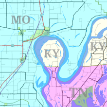
 Location of New Madrid, Missouri | |
| Coordinates: 36°35′16″N 89°33′02″W / 36.58778°N 89.55056°W | |
| Country | United States |
| State | Missouri |
| County | New Madrid |
| Area | |
| • Total | 4.54 sq mi (11.75 km2) |
| • Land | 4.50 sq mi (11.66 km2) |
| • Water | 0.04 sq mi (0.09 km2) |
| Elevation | 292 ft (89 m) |
| Population (2020) | |
| • Total | 2,787 |
| • Density | 619.20/sq mi (239.05/km2) |
| Time zone | UTC−6 (Central (CST)) |
| • Summer (DST) | UTC−5 (CDT) |
| ZIP code | 63869 |
| Area code | 573 |
| FIPS code | 29-52076[3] |
| GNIS feature ID | 2395206[2] |
| Website | new-madrid.mo.us |
New Madrid (/ˈmædrɪd/ MAD-rid; Spanish: Nueva Madrid) is a city in New Madrid County, Missouri, United States. The population was 2,787 at the 2020 census. New Madrid is the county seat of New Madrid County.[4] The city is located 42 miles (68 km) southwest of Cairo, Illinois, and north of an exclave of Fulton County, Kentucky, across the Mississippi River.

The town is on the north side of the Kentucky Bend in the Mississippi River, which is also known as "New Madrid Bend" or "Madrid Bend." The river curves in an oxbow around an exclave of Fulton County, Kentucky. Scientists expect the river eventually to cut across the neck of the peninsula and make a more direct channel, leaving the Kentucky territory as an island.
New Madrid was the epicenter of the very powerful 1811–12 New Madrid earthquakes.
- ^ "ArcGIS REST Services Directory". United States Census Bureau. Retrieved August 28, 2022.
- ^ a b U.S. Geological Survey Geographic Names Information System: New Madrid, Missouri
- ^ "U.S. Census website". United States Census Bureau. Retrieved January 31, 2008.
- ^ "Find a County". National Association of Counties. Retrieved June 7, 2011.
