New Taipei City
新北市[I] Hsinpei City, Hsinpei, Hsin-Pei | |
|---|---|
Clockwise from top: Panoramic view of the skyline of New Taipei City, Shifen Waterfall, TRA Pingxi Line, Bitan Suspension Bridge, Sunset of Tamsui, Jiufen Old Street at night and New Taipei City Government | |
| Etymology: Chinese: 新北; lit. 'New north' | |
 | |
 | |
| Coordinates: 25°00′40″N 121°26′45″E / 25.01111°N 121.44583°E | |
| Country | Taiwan |
| Part of Taihoku Prefecture | 17 April 1895 |
| Taipei County | 7 January 1946 |
| Special municipality status | 25 December 2010 |
| Seat | Banqiao District |
| Districts | |
| Government | |
| • Body | |
| • Mayor | Hou Yu-ih (KMT) |
| Area | |
| 2,052.57 km2 (792.50 sq mi) | |
| • Urban | 1,140 km2 (440 sq mi) |
| • Rank | 9 out of 22 |
| Population (January 2023)[3] | |
| 4,004,367 | |
| • Rank | 1 out of 22 |
| • Density | 2,000/km2 (5,100/sq mi) |
| • Urban | 8,535,000 |
| • Urban density | 7,500/km2 (19,000/sq mi) |
| Time zone | UTC+8 (National Standard Time) |
| Postal code | 207, 208, 220 – 224, 226 – 228, 231 – 239, 241 – 244, 247 – 249, 251 – 253 |
| Area code | (0)2 |
| ISO 3166 code | TW-NWT |
| Website | foreigner |
| New Taipei City | |||||||||||||||||||||||||||||||||
|---|---|---|---|---|---|---|---|---|---|---|---|---|---|---|---|---|---|---|---|---|---|---|---|---|---|---|---|---|---|---|---|---|---|
| Chinese | 新北市 | ||||||||||||||||||||||||||||||||
| Literal meaning | New North City | ||||||||||||||||||||||||||||||||
| |||||||||||||||||||||||||||||||||
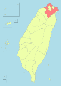
New Taipei City[I] is a special municipality located in northern Taiwan. The city is home to an estimated population of 4,004,367 as of January 2023,[3] making it the most populous city in Taiwan, and also the second largest special municipality by area, behind Kaohsiung. The top-level administrative divisions bordering New Taipei City are Keelung to the northeast, Yilan County to the southeast, and Taoyuan to the southwest, and it completely encloses the city of Taipei. Banqiao District is its municipal seat and biggest commercial area.
Before the Spanish and Dutch started arriving in Taiwan and set up small outposts in Tamsui in 1626, the area of present-day New Taipei City was mostly inhabited by Taiwanese indigenous peoples, mainly the Ketagalan people. From the late Qing era, the port of Tamsui was opened up to foreign traders as one of the treaty ports after the Qing dynasty of China signed the Treaty of Tientsin in June 1858. By the 1890s, the port of Tamsui accounted for 63 percent of the overall trade for entire Taiwan,[5] port towns in the middle course of Tamsui River had also developed into bustling business and transportation centers. During the Japanese rule of Taiwan, the entire area of New Taipei City was organized as part of the Taihoku Prefecture. After the Republic of China took control of Taiwan in 1945, the present-day New Taipei City was designated on 7 January 1946 as Taipei County in Taiwan Province, which was constituted from the former Taihoku Prefecture, but not including present-day divisions of Taipei City, Keelung and Yilan County, the latter which became detached from Taipei County on 10 October 1950. Its county status remained until 25 December 2010 when it was promoted to special municipal status and renamed as "New Taipei City".
New Taipei City is a conurbation which was merged from numbers of regiopolis, suburban business districts or commuter towns to form one continuous polycentric urban area. Together with cities of Taipei and Keelung, New Taipei City constitutes most of the Taipei-Keelung metropolitan area which spans from the island's northern coastline to the mountainous Xueshan Range, and encompasses the entire Taipei Basin within its boundaries. The city is well-connected to other major cities in proximity or other parts of the island by various public transports such as Metro services, high-speed rail and an airport line commuting to Taoyuan International Airport, a major hub airport in northern Taiwan. The Port of Taipei, an artificial international seaport, is situated in the northwestern coast of the city in Bali District.
Cite error: There are <ref group=upper-roman> tags on this page, but the references will not show without a {{reflist|group=upper-roman}} template (see the help page).
- ^ 《中華民國統計資訊網》縣市重要統計指標查詢系統網 (in Traditional Chinese). Archived from the original on 12 June 2016. Retrieved 13 June 2016.
- ^ "Demographia World Urban Areas PDF (April 2016)" (PDF). Demographia. Archived (PDF) from the original on 3 May 2018. Retrieved 13 June 2016.
- ^ a b 人口統計(110年12月)列表 (in Chinese (Taiwan)). Department of civil affairs, New Taipei City Government. 10 January 2018. Archived from the original on 21 January 2022. Retrieved 20 January 2022.
- ^ "Demographia World Urban Areas PDF" (PDF). Demographia. Archived (PDF) from the original on 3 May 2018. Retrieved 30 November 2019.
- ^ "Reclaiming The Tamsui River". Taiwan Today. 1 July 1987. Archived from the original on 13 November 2022. Retrieved 12 November 2022.


