| Newberry National Volcanic Monument | |
|---|---|
 | |
| Location | Deschutes County, Oregon, United States |
| Nearest city | Bend |
| Coordinates | 43°41′39″N 121°15′07″W / 43.69417°N 121.25194°W |
| Area | 54,822 acres (221.86 km2)[1] |
| Created | November 5, 1990[1] |
| Governing body | U.S. Forest Service |
| Website | Newberry National Volcanic Monument |
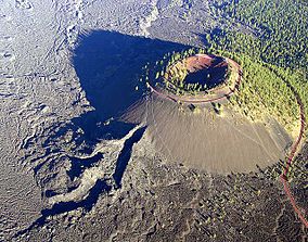
Newberry National Volcanic Monument was designated on November 5, 1990, to protect the area around the Newberry Volcano in the U.S. state of Oregon.[2] The monument was created within the boundaries of the Deschutes National Forest, which is managed by the U.S. Forest Service, and includes 54,822 acres (86 sq mi; 222 km2) of lakes, lava flows, and geologic features in central Oregon.
From 1964 to 1966, the volcano was used for training Apollo astronauts.[3]
- ^ a b "Other Congressionally Designated Areas". U.S. Forest Service. November 1, 2007. Retrieved October 4, 2011.
- ^ Newberry National Volcanic Monument, Oregon, Act, PL 101–522, November 5, 1990, 104 Stat 2288.
- ^ Phinney, William C. (2015), Science Training History of the Apollo Astronauts (PDF), NASA, pp. 220–223, NASA/SP-2015-626

