Newbury, New Hampshire | |
|---|---|
 | |
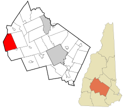
 Location in Merrimack County and the state of New Hampshire. | |
| Coordinates: 43°19′17″N 72°02′09″W / 43.32139°N 72.03583°W | |
| Country | United States |
| State | New Hampshire |
| County | Merrimack |
| Incorporated | 1778[1] |
| Villages | |
| Government | |
| • Selectboard |
|
| Area | |
• Total | 38.1 sq mi (98.7 km2) |
| • Land | 35.8 sq mi (92.8 km2) |
| • Water | 2.3 sq mi (5.9 km2) 5.94% |
| Elevation | 1,155 ft (352 m) |
| Population (2020)[3] | |
• Total | 2,172 |
| • Density | 61/sq mi (23.4/km2) |
| Time zone | UTC-5 (Eastern) |
| • Summer (DST) | UTC-4 (Eastern) |
| ZIP codes | 03255 (Newbury, Mount Sunapee) 03272 (South Newbury) |
| Area code | 603 |
| FIPS code | 33-50900 |
| GNIS feature ID | 873675[4] |
| Website | www |
Newbury is a town in Merrimack County, New Hampshire, United States. The population was 2,172 at the 2020 census.[3]
The town includes the villages of Newbury, Blodgett Landing and South Newbury, as well as a portion of Mount Sunapee Resort, a ski area, and a portion of Lake Sunapee, including the beach at Mount Sunapee State Park.
- ^ "About Us". Town of Newbury, New Hampshire. Retrieved April 17, 2024.
- ^ Cite error: The named reference
CenPopGazetteer2023was invoked but never defined (see the help page). - ^ a b "Newbury town, Merrimack County, New Hampshire: 2020 DEC Redistricting Data (PL 94-171)". U.S. Census Bureau. Retrieved April 16, 2024.
- ^ U.S. Geological Survey Geographic Names Information System: Town of Newbury
