| Newry Canal | |
|---|---|
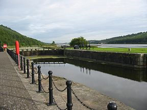
 Victoria Lock at the entrance to Newry ship canal in Carlingford Lough | |
 | |
| Specifications | |
| Maximum boat length | 13.4 m (43 ft 11.6 in) |
| Maximum boat beam | 15.47 m (50 ft 9 in) |
| Locks | 14 (originally 13) |
| Maximum height above sea level | 23.8 m (78 ft) |
| Status | abandoned |
| History | |
| Principal engineer | Edward Lovett Pearce, Richard Castle, Thomas Steers |
| Date completed | 1741 |
| Date closed | 1949, 1970s |
| Geography | |
| Start point | Newry |
| End point | Portadown |
Newry Canal | |||||||||||||||||||||||||||||||||||||||||||||||||||||||||||||||||||||||||||||||||||||||||||||||||||||||||||||||||||||||||||||||||||||||||||||||||||||||||||||||||||||||||||||||||||||||||||||||||||||||||||||||||||||||||||||||||||||||||||||||||||||||||||||||||||
|---|---|---|---|---|---|---|---|---|---|---|---|---|---|---|---|---|---|---|---|---|---|---|---|---|---|---|---|---|---|---|---|---|---|---|---|---|---|---|---|---|---|---|---|---|---|---|---|---|---|---|---|---|---|---|---|---|---|---|---|---|---|---|---|---|---|---|---|---|---|---|---|---|---|---|---|---|---|---|---|---|---|---|---|---|---|---|---|---|---|---|---|---|---|---|---|---|---|---|---|---|---|---|---|---|---|---|---|---|---|---|---|---|---|---|---|---|---|---|---|---|---|---|---|---|---|---|---|---|---|---|---|---|---|---|---|---|---|---|---|---|---|---|---|---|---|---|---|---|---|---|---|---|---|---|---|---|---|---|---|---|---|---|---|---|---|---|---|---|---|---|---|---|---|---|---|---|---|---|---|---|---|---|---|---|---|---|---|---|---|---|---|---|---|---|---|---|---|---|---|---|---|---|---|---|---|---|---|---|---|---|---|---|---|---|---|---|---|---|---|---|---|---|---|---|---|---|---|---|---|---|---|---|---|---|---|---|---|---|---|---|---|---|---|---|---|---|---|---|---|---|---|---|---|---|---|---|---|---|---|
| |||||||||||||||||||||||||||||||||||||||||||||||||||||||||||||||||||||||||||||||||||||||||||||||||||||||||||||||||||||||||||||||||||||||||||||||||||||||||||||||||||||||||||||||||||||||||||||||||||||||||||||||||||||||||||||||||||||||||||||||||||||||||||||||||||
The Newry Canal is an abandoned canal in Northern Ireland. Opened in 1742, it was built to link the Tyrone coalfields to the Irish Sea. The navigable route ran from Lough Neagh via the Upper Bann river to Portadown (approximated 9 miles), then approximately 20 miles from Portadown via the canal proper to Newry, terminating in the Albert Basin.
The canal was closed to navigation in 1949, however its line remains intact and the towpath is currently part of the National Cycle Network and the Ulster Way long distance footpath.
The Newry Ship Canal (opened in 1769), runs approximately 3½ miles south from Newry's Albert Basin to connect with the sea at Carlingford Lough. The Newry Ship Canal remains navigable by pleasure craft today.