| Niagara Park Central Coast, New South Wales | |||||||||||||||
|---|---|---|---|---|---|---|---|---|---|---|---|---|---|---|---|
 Niagara Park Station | |||||||||||||||
 | |||||||||||||||
| Coordinates | 33°22′55″S 151°21′04″E / 33.382°S 151.351°E | ||||||||||||||
| Population | 2,743 (2016 census)[1] | ||||||||||||||
| • Density | 1,143/km2 (2,960/sq mi) | ||||||||||||||
| Postcode(s) | 2250 | ||||||||||||||
| Elevation | 23 m (75 ft) | ||||||||||||||
| Area | 2.4 km2 (0.9 sq mi) | ||||||||||||||
| Location |
| ||||||||||||||
| LGA(s) | Central Coast Council | ||||||||||||||
| Parish | Gosford | ||||||||||||||
| State electorate(s) | The Entrance | ||||||||||||||
| Federal division(s) | Dobell | ||||||||||||||
| |||||||||||||||
Niagara Park is a suburb of the Central Coast region of New South Wales, Australia 6 kilometres (4 mi) north of Gosford's central business district. It is part of the Central Coast Council local government area. It consists of residential housing as well as acreage blocks and small farms with many houses backing onto natural bushland and reserves. It is close to the M1 and is 20 minutes from Shelly Beach. A peaceful community with rural aspects and a large technology driven primary school, Niagara Park is ideal for families with young children.
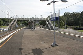
The suburb contains Niagara Park railway station, which is on the Main North railway line. A shopping centre, timber mill, primary school, and sports centre are also located within Niagara Park.
- ^ Australian Bureau of Statistics (27 June 2017). "Niagara Park (State Suburb)". 2016 Census QuickStats. Retrieved 19 March 2018.
