Nicobar district | |
|---|---|
| Coordinates: 9°09′26″N 92°45′40″E / 9.157343°N 92.761087°E | |
| Country | |
| Union territory | |
| Formation | 1 August 1974 |
| headquarter | Car Nicobar |
| Time zone | UTC+5:30 (IST) |
| PIN | 744301 |
| Telephone code | 03192 |
| Sex ratio | 1.2♂/♀ |
| Literacy | 84.4% |
| Website | https://nicobars.andaman.nic.in/ |
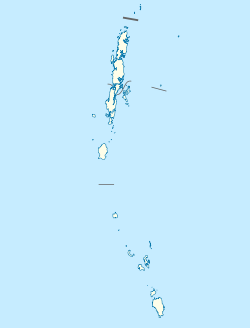
Location in the Bay of Bengal. | |
| Geography | |
|---|---|
| Location | Bay of Bengal |
| Archipelago | Nicobar Islands |
| Adjacent to | Indian Ocean |
| Total islands | 30 |
| Major islands | |
| Area | 1,648.13 km2 (636.35 sq mi)[1] |
| Highest elevation | 642 m (2106 ft) |
| Demographics | |
| Population | 36,842 (2011) |
| Pop. density | 22.3/km2 (57.8/sq mi) |
| Ethnic groups | Hindu, Nicobarese |
| Additional information | |
| Avg. summer temperature | 30.2 °C (86.4 °F) |
| Avg. winter temperature | 23.0 °C (73.4 °F) |
| Census Code | 35.638.0001 |
| Official Languages | Hindi, English, Car (regional) |
Nicobar district is one of three districts in the Indian union territory of the Andaman and Nicobar Islands. The district's administrative territory encompasses all of the Nicobar Islands, which are located in the Indian Ocean, between the Bay of Bengal and the Andaman Sea. The headquarters of the district is the village of Malacca, located on the island of Car Nicobar.
The district administration is headed by a Deputy Commissioner, who in turn reports to the Lt. Governor of the Andaman and Nicobar Islands.
It is the fifth least populous district in the country (out of 640).[2]
- ^ "Islandwise Area and Population - 2011 Census" (PDF). Government of Andaman. Archived from the original (PDF) on 2017-08-28. Retrieved 2016-05-09.
- ^ "District Census 2011". Census2011.co.in. 2011. Retrieved 2011-09-30.


