Niederwald, Texas | |
|---|---|
 Niederwald City Hall | |
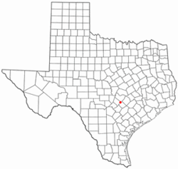
 Location of Niederwald, Texas | |
 | |
| Coordinates: 30°00′23″N 97°45′00″W / 30.00639°N 97.75000°W | |
| Country | United States |
| State | Texas |
| Counties | Hays, Caldwell |
| Incorporated | 1987 |
| Area | |
| • Total | 3.67 sq mi (9.50 km2) |
| • Land | 3.67 sq mi (9.50 km2) |
| • Water | 0.00 sq mi (0.00 km2) |
| Elevation | 574 ft (175 m) |
| Population (2020) | |
| • Total | 668 |
| • Density | 180/sq mi (70/km2) |
| Time zone | UTC-6 (Central (CST)) |
| • Summer (DST) | UTC-5 (CDT) |
| ZIP code | 78640 |
| Area code | 512 |
| FIPS code | 48-51492[3] |
| GNIS feature ID | 2411256[2] |
| Website | www |
Niederwald is a city in Caldwell and Hays counties in the U.S. state of Texas.[4] The population was 668 at the 2020 census. Niederwald means "low forest", or "low wood", in German. It was named Niederwald by the German founders of the town. This region of Central Texas was settled in the 1800s primarily by Germans and European emigrants and is referred to as the Texas-German belt by locals.[5]
- ^ "2019 U.S. Gazetteer Files". United States Census Bureau. Retrieved August 7, 2020.
- ^ a b U.S. Geological Survey Geographic Names Information System: Niederwald, Texas
- ^ "U.S. Census website". United States Census Bureau. Retrieved January 31, 2008.
- ^ US Census change list Archived 2006-02-06 at the Wayback Machine
- ^ https://cityofniederwald.org/#:~:text=Built%20along%20the%20old%20Austin,as%20a%20city%20in%201987. [bare URL]