| Niles Canyon Alameda Canyon | |
|---|---|
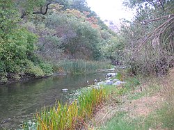
 Alameda Creek in Niles Canyon | |
 | |
| Native name | Cañada Molina Vallejo (Spanish) |
| Location | |
| Country | United States |
| State | California |
| Region | Alameda County |
| Physical characteristics | |
| Source | head |
| • location | at Sunol, California |
| • coordinates | 37°35′40″N 121°53′56″W / 37.59444°N 121.89889°W[1] |
| Mouth | mouth |
• location | at Niles, California |
• coordinates | 37°34′50″N 121°57′55″W / 37.58056°N 121.96528°W[1] |
• elevation | 82 ft (25 m) |
Niles Canyon is a canyon in the San Francisco Bay Area formed by Alameda Creek, known for its heritage railroad and silent movie history. The canyon is largely in an unincorporated area of Alameda County, while the western portion of the canyon lies within the city limits of Fremont and Union City. The stretch of State Route 84 known as Niles Canyon Road traverses the length of the canyon from the Niles district of Fremont to the unincorporated town of Sunol. Two railroads also follow the same route down the canyon from Sunol to Niles: the old Southern Pacific track along the north side, now the Niles Canyon Railway, and the newer Union Pacific (formerly the Western Pacific) track a little to the south. At the west end of the canyon are the ruins of the Vallejo Flour Mill, which dates to 1853.