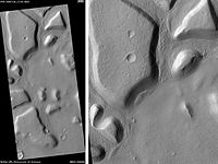
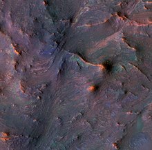
 Astapus Colles Mounds and Knobs, as seen by HiRISE. Scale bar is 500 meters long. | |
| Coordinates | 36°52′N 67°54′E / 36.87°N 67.9°E |
|---|---|
| Dimensions | 705 km across |
| Naming | a classical albedo feature |


Nilosyrtis Mensae is an area of Mars in the Casius quadrangle. It is centered on the coordinates of 36.87° N and 67.9° E. Its western and eastern longitudes are 51.1° E and 74.4° E. North and south latitudes are 36.87° N and 29.61° N.[2] Nilosyrtis Mensae is just to the east of Protonilus Mensae and both lie along the Martian dichotomy boundary. Its name was adapted by the IAU in 1973. It was named after a classical albedo feature, and it is 705 km (438 mi) across.
The surface of Nilosyrtis Mensae is classified as fretted terrain. This terrain contains cliffs, mesas, and wide flat valleys. Surface features are believed to have been caused by debris-covered glaciers.[3][4] These glaciers are termed lobate debris aprons when surrounding mounds and mesas.[5][6][7][8] When the glaciers are in the valleys they are called lineated valley fill.[9][10][11][12]
- ^ The Color Palette of Nilosyrtis Mensae at University of Arizona/HiRISE
- ^ "Nilosyrtis Mensae". Gazetteer of Planetary Nomenclature. USGS Astrogeology Research Program.
- ^ Greeley, R. and J. Guest. 1987. Geological map of the eastern equatorial region of Mars, scale 1:15,000,000. U. S. Geol. Ser. Misc. Invest. Map I-802-B, Reston, Virginia
- ^ Sharp, R. 1973. Mars Fretted and chaotic terrains. J. Geophys. Res.: 78. 4073-4083
- ^ Plaut, J. et al. 2008. Radar Evidence for Ice in Lobate Debris Aprons in the Mid-Northern Latitudes of Mars. Lunar and Planetary Science XXXIX. 2290.pdf
- ^ Carr, M. 2006. The Surface of Mars. Cambridge University Press. ISBN 978-0-521-87201-0
- ^ Squyres, S. 1978. Martian fretted terrain: Flow of erosional debrid. Icarus: 34. 600-613.
- ^ ISBN 0-8165-1257-4
- ^ Morgan, G. and J. Head III. 2009. Sinton crater, Mars: Evidence for impact into a plateau icefield and melting to produce valley networks at the Hesperian-Amazonian boundary. Icarus: 202. 39–59.
- ^ Morgan, G. et al. 2009. Lineated valley fill (LVF) and lobate debris aprons (LDA) in the Deuteronilus Mensae northern dichotomy boundary region, Mars: Constraints on the extent, age, and episodicity of Amazonian glacial events. Icarus: 202. 22–38.
- ^ Head, J., et al. 2006. Extensive valley glacier deposits in the northern mid-latitudes of Mars: Evidence for the late Amazonian obliquity-driven climate change. Earth Planet. Sci. Lett. 241. 663-671
- ^ Head, J., et al. 2006. Modification if the dichotomy boundary on Mars by Amazonian mid-latitude regional glaciation. Geophys. Res Lett. 33