| Nimelen Нимелен | |
|---|---|
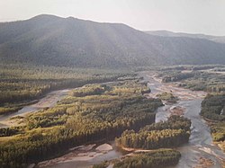
 Upper course in the Yam-Alin area. | |
Mouth location in Khabarovsk Krai, Russia | |
| Location | |
| Country | Russia |
| Physical characteristics | |
| Source | |
| • location | Confluence of Mata and Seyamni-Makit Yam-Alin |
| • coordinates | 52°54′58″N 134°49′59″E / 52.91611°N 134.83306°E |
| Mouth | Amgun |
• coordinates | 52°25′57″N 136°35′27″E / 52.43250°N 136.59083°E |
• elevation | 51 m (167 ft) |
| Length | 311 km (193 mi) |
| Basin size | 14,100 km2 (5,400 sq mi) |
| Discharge | |
| • average | 157 m3/s (5,500 cu ft/s) |
| Basin features | |
| Progression | Amgun → Amur→ Sea of Okhotsk |
The Nimelen (‹See Tfd›Russian: Нимелен) is a river in Khabarovsk Krai, Russia. It is the longest tributary of the Amgun, with a length of 311 kilometres (193 mi)[1] and a drainage basin area of 14,100 square kilometres (5,400 sq mi).[2][3]
The Nimelen flows across a desolate, uninhabited area where the climate is harsh.[1]
- ^ a b Water of Russia - Нимелен
- ^ "Река Нимелен (Немилен) in the State Water Register of Russia". textual.ru (in Russian).
- ^ Нимелен — Great Soviet Encyclopedia : (in 30 vols.) - Ch. ed. A.M. Prokhorov. - 3rd ed. - M .: Soviet Encyclopedia, 1969-1978.
