| Nimishillen Creek | |
|---|---|
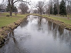
 West Branch Nimishillen Creek in a city park in Canton in 2006 | |
 | |
| Location | |
| Country | United States |
| State | Ohio |
| Physical characteristics | |
| Source | |
| • location | Canton, Ohio, confluence of East and Middle Branches[2] |
| • coordinates | 40°48′24″N 81°21′14″W / 40.80667°N 81.35389°W[1] |
| Mouth | |
• location | Sandy Creek in Tuscarawas County, Ohio[2] |
• elevation | 938 ft (286 m)[1] |
| Length | 24.5 mi (39.4 km)[3] |
| Basin size | 187 sq mi (480 km2)[5] |
| Discharge | |
| • location | USGS gauge at North Industry |
| • average | 211.1 cu ft/s (5.98 m3/s), water years 1922-2019[4] |
Nimishillen Creek is a tributary of Sandy Creek, 24.5 miles (39.4 km) long, in northeastern Ohio. Via Sandy Creek and the Tuscarawas, Muskingum and Ohio Rivers, it is part of the watershed of the Mississippi River, draining an area of 187 square miles (484 km²), including the city of Canton.[2]
- ^ a b "Geographic Names Information System entry for Nimishillen Creek". Retrieved 2007-01-13.
- ^ a b c DeLorme (1991). Ohio Atlas & Gazetteer. Yarmouth, Maine: DeLorme. ISBN 0-89933-233-1.
- ^ Eric Akin, Upper Tuscarawas River Watershed Coordinator (2006-06-21). "Nimishillen Creek Watershed - State Action Plan" (PDF). pp. p.25. Retrieved 2007-01-13.
- ^ "Water-Year Summary for Site 03118500". waterdata.usgs.gov. Archived from the original on 2020-08-12. Retrieved 2020-08-12.
- ^ Ohio Department of Natural Resources. "Major Ohio Watersheds" (PDF). A Guide to Ohio Streams. pp. p. 11. Archived from the original (PDF) on 2006-12-09. Retrieved 2007-01-13.