Nineveh Governorate
محافظة نينوى (Arabic) | |
|---|---|
|
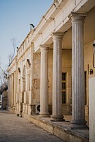
Top-bottom, R–L: View over Tigris river Church of Saint Thomas • Hatra Mosul Rural area • The river's gate Mosul Museum • Heritage house | |
 | |
| Coordinates: 36°0′N 42°28′E / 36.000°N 42.467°E | |
| Country | |
| Capital | Mosul |
| Government | |
| • Governor | Abdul Qader al-Dakheel |
| Area | |
| • Total | 37,323 km2 (14,410 sq mi) |
| Population (Estimate 2018[1]) | |
| • Total | 3,730,000[1] |
| ISO 3166 code | IQ-NI |
| HDI (2021) | 0.695[2] medium |
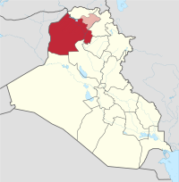
Nineveh or Ninawa Governorate (Arabic: محافظة نينوى, romanized: muḥāfaẓat Naynawā;[3] Syriac: ܗܘܦܪܟܝܐ ܕܢܝܢܘܐ, romanized: Hoparkiya d’Ninwe,[4][5] Sorani Kurdish: پارێزگای نەینەوا, romanized: Parêzgeha Neynewa[6][7]) is a governorate in northern Iraq. It has an area of 37,323 km2 (14,410 sq mi) and an estimated population of 2,453,000 people as of 2003. Its largest city and provincial capital is Mosul, which lies across the Tigris river from the ruins of ancient Nineveh. Before 1976, it was called Mosul Province and included the present-day Dohuk Governorate.[8] The second largest city is Tal Afar, which has an almost exclusively Turkmen population.[9]
An ethnically, religiously and culturally diverse region, it was partly conquered by ISIS in 2014.[10] Iraqi government forces retook the city of Mosul in 2017.[11][12]
- ^ a b "Nīnawā (Governorate, Iraq) – Population Statistics, Charts, Map and Location".
- ^ "Sub-national HDI – Area Database – Global Data Lab". hdi.globaldatalab.org. Retrieved 13 September 2018.
- ^ "محافظة نينوى". ninava.gov.iq (in Arabic). Retrieved 21 December 2019.
- ^ "Bahra Magazine" (PDF). zowaa.co.uk/bahra/s145-1.pdf (in Syriac). Retrieved 27 April 2020.
- ^ Gregorius bar Hebraeus, “” based upon Jean Baptiste Abbeloos and Thomas Joseph Lamy (eds.), Gregorii Barhebræi (Louvain: Peeters, 1872–1877), Digital Syriac Corpus, last modified 4 May 2018, https://syriaccorpus.org/373.
- ^ "PDK û rewşa Civata Parêzgeha Neynewa di perlemana Îraqê de". Kurdistan24 (in Kurdish). Retrieved 21 December 2019.
- ^ "ئەنجوومەنی پارێزگای نەینەوا: پارێزگار دەستیلەکارکێشایەوە و پەسەندمان کرد" (in Kurdish). 19 November 2019. Retrieved 21 December 2019.
- ^ "Ninewa – NCCI Governorate Profile" (PDF). 2010. p. 4. Retrieved 21 December 2019.
- ^ "The Ba'ath Party and Insurgency in Tal Afar" (PDF).
- ^ al-Lami, Mina (21 July 2014). "Iraq: the minorities of Nineveh Plain". BBC News. Archived from the original on 24 July 2014.
- ^ "العبادي يطلق على عمليات تحرير نينوى تسمية "قادمون يا نينوى" أمن". Al Sumaria. 17 October 2016. Retrieved 21 October 2016.
- ^ Winter, Charlie (20 October 2016). "How ISIS Is Spinning the Mosul Battle". The Atlantic. Retrieved 21 October 2016.


