| Ninnescah River | |
|---|---|
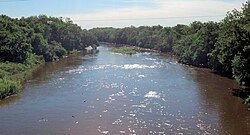
 Ninnescah River at Peck, Kansas | |
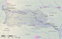
 Map of the Arkansas River watershed including the Ninnescah River | |
| Location | |
| Country | United States |
| State | Kansas |
| Physical characteristics | |
| Source confluence | |
| • location | Sedgwick County, Kansas |
| • coordinates | 37°34′05″N 97°42′19″W / 37.56806°N 97.70528°W |
| • elevation | 1,302 ft (397 m) |
| Mouth | Arkansas River |
• location | Sumner County, Kansas |
• coordinates | 37°19′17″N 97°09′59″W / 37.32139°N 97.16639°W[1] |
• elevation | 1,152 ft (351 m) |
| Length | 56 mi (90 km) |
| Basin size | 2,129 sq mi (5,510 km2) |
| Discharge | |
| • location | USGS 07145500 near Peck, KS[2] |
| • average | 522 cu ft/s (14.8 m3/s) |
| • minimum | 0.2 cu ft/s (0.0057 m3/s) |
| • maximum | 33,700 cu ft/s (950 m3/s) |
| Basin features | |
| Tributaries | |
| • left | North Fork Ninnescah River |
| • right | South Fork Ninnescah River |
| Watersheds | Ninnescah-Arkansas- Mississippi |
The Ninnescah River is a river in the central Great Plains of North America. Its entire 56.4-mile (90.8 km) length lies within the U.S. state of Kansas. It is a tributary of the Arkansas River.[3]
- ^ "Ninnescah River". Geographic Names Information System. United States Geological Survey, United States Department of the Interior. Retrieved 2015-10-19.
- ^ "Water-Data Report 2013 - 07145500 Ninnescah River Near Peck, KS" (PDF). U.S. Geological Survey. Retrieved 2015-10-19.
- ^ U.S. Geological Survey. National Hydrography Dataset high-resolution flowline data. The National Map, accessed March 29, 2011