| Nisqually River | |
|---|---|
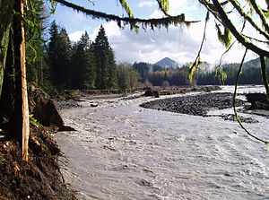
 Nisqually River near Ashford during a flood in 2006 that destroyed a campground in Mount Rainier National Park | |
| Location | |
| Country | United States |
| State | Washington |
| District | Nisqually Indian Reservation, Fort Lewis |
| Physical characteristics | |
| Source | Nisqually Glacier |
| • location | Mount Rainier |
| • coordinates | 46°47′39″N 121°44′54″W / 46.79417°N 121.74833°W[1] |
| • elevation | 4,809 ft (1,466 m)[2] |
| Mouth | Puget Sound |
• location | Nisqually National Wildlife Refuge |
• coordinates | 47°6′31″N 122°42′11″W / 47.10861°N 122.70306°W[1] |
• elevation | 0 ft (0 m) |
| Length | 81 mi (130 km) |
| Basin size | 517 sq mi (1,340 km2)[3] |
| Discharge | |
| • location | La Grande, WA[4] |
| • average | 1,460 cu ft/s (41 m3/s)[4] |
| • minimum | 460 cu ft/s (13 m3/s) |
| • maximum | 39,500 cu ft/s (1,120 m3/s) |
| Basin features | |
| Tributaries | |
| • left | Little Nisqually River |
| • right | Mashel River |

The Nisqually River /nɪˈskwɑːli/ is a river in west central Washington in the United States, approximately 81 miles (130 km) long. It drains part of the Cascade Range southeast of Tacoma, including the southern slope of Mount Rainier, and empties into the southern end of Puget Sound. Its outlet was designated in 1971 as the Nisqually Delta National Natural Landmark.
The Nisqually River forms the Pierce–Lewis county line, as well as the boundary between Pierce and Thurston counties.
- ^ a b United States Geological Survey; U.S. Geological Survey Geographic Names Information System: Nisqually River; retrieved April 20, 2007.
- ^ Google Earth elevation for GNIS source coordinates. Retrieved April 20, 2007.
- ^ United States Geological Survey; Nisqually River at McKenna, WA; retrieved April 20, 2007.
- ^ a b United States Geological Survey; Nisqually River at La Grande, WA; retrieved April 20, 2007 (used instead of McKenna gage due to power canal river diversion).

