| Nizhnyaya Tunguska Lower Tunguska | |
|---|---|
 | |
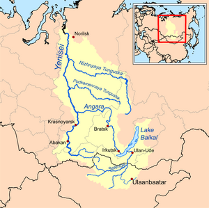
 Map of the Yenisey basin that shows the Nizhnyaya Tunguska river | |
| Native name | Нижняя Тунгуска (Russian) |
| Location | |
| Country | Russia |
| Federal subject | Krasnoyarsk Krai, Irkutsk Oblast |
| Cities | Turukhansk, Tura, Erbogachen |
| Physical characteristics | |
| Source | Angara Range, Central Siberian Plateau |
| • location | Ust-Kutsky District, Irkutsk Oblast |
| • coordinates | 58°01′52″N 105°42′07″E / 58.031°N 105.702°E |
| • elevation | 521 m (1,709 ft) |
| Mouth | Yenisey |
• location | Turukhansk, Turukhansky District |
• coordinates | 65°46′16″N 87°57′07″E / 65.771°N 87.952°E |
• elevation | 1 m (3.3 ft) |
| Length | 2,989 km (1,857 mi) |
| Basin size | 473,000 km2 (183,000 sq mi) |
| Discharge | |
| • location | mouth[1] |
| • average | 3,680 m3/s (130,000 cu ft/s) |
| • minimum | 1 m3/s (35 cu ft/s) |
| • maximum | 112,000 m3/s (4,000,000 cu ft/s) |
| Basin features | |
| Progression | Yenisey→ Kara Sea |
| Tributaries | |
| • right | Kochechum |
The Nizhnyaya Tunguska (Russian: Ни́жняя Тунгу́ска, IPA: [ˈnʲiʐnʲɪjə tʊnˈɡuskə], meaning "Lower Tunguska") is a river in Siberia, Russia, that flows through the Irkutsk Oblast and the Krasnoyarsk Krai. The river is a right tributary of the Yenisey joining it at Turukhansk (see Siberian River Routes). The ice-free period on the Nizhnyaya Tunguska starts in mid-June and ends in the first half of October. The river forms the western limit of the Lena Plateau.
- ^ (in Russian) Нижняя Тунгуска, Словарь современных географических названий