This article contains too many pictures for its overall length. (November 2024) |
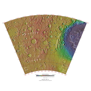
 Map of Noachis quadrangle from Mars Orbiter Laser Altimeter (MOLA) data. The highest elevations are red and the lowest are blue. | |
| Coordinates | 47°30′S 330°00′W / 47.5°S 330°W |
|---|---|

The Noachis quadrangle is one of a series of 30 quadrangle maps of Mars used by the United States Geological Survey (USGS) Astrogeology Research Program. The Noachis quadrangle is also referred to as MC-27 (Mars Chart-27).[1]
The Noachis quadrangle covers the area from 300° to 360° west longitude and 30° to 65° south latitude on Mars. It lies between the two giant impact basins on Mars: Argyre and Hellas. The Noachis quadrangle includes Noachis Terra and the western part of Hellas Planitia.
Noachis is so densely covered with impact craters that it is considered among the oldest landforms on Mars—hence the term "Noachian" for one of the earliest time periods in martian history. In addition, many previously buried craters are now coming to the surface,[2] where Noachis' extreme age has allowed ancient craters to be filled, and once again newly exposed.
Much of the surface in Noachis quadrangle shows a scalloped topography where the disappearance of ground ice has left depressions.[3]
The first piece of human technology to land on Mars landed (crashed) in the Noachis quadrangle. The Soviet's Mars 2 crashed at 44°12′S 313°12′W / 44.2°S 313.2°W. It weighed about one ton. The automated craft attempted to land in a giant dust storm. To make conditions even worse, this area also has many dust devils.[4]
- ^ Davies, M.E.; Batson, R.M.; Wu, S.S.C. "Geodesy and Cartography" in Kieffer, H.H.; Jakosky, B.M.; Snyder, C.W.; Matthews, M.S., Eds. Mars. University of Arizona Press: Tucson, 1992.
- ^ Mars Space Flight Facility (17 March 2004). "Exhumed Crater (Released 17 March 2004)". Arizona State University. Archived from the original on 27 September 2011. Retrieved 19 December 2011.
- ^ Lefort, A.; et al. (2010). "Scalloped terrains in the Peneus and Amphitrites Paterae region of Mars as observed by HiRISE". Icarus. 205 (1): 259–268. Bibcode:2010Icar..205..259L. doi:10.1016/j.icarus.2009.06.005.
- ^ Hartmann, W. 2003. A Traveler's Guide to Mars. Workman Publishing. NY, NY.[page needed]