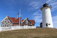
 Nobska Light in 2016 | |
 | |
| Location | Nobska Rd., Woods Hole, Massachusetts |
|---|---|
| Coordinates | 41°30′56.9″N 70°39′18.4″W / 41.515806°N 70.655111°W |
| Tower | |
| Constructed | 1829 |
| Foundation | Natural Emplaced |
| Construction | Iron with brick lining |
| Automated | 1985 |
| Height | 40 feet (12 m) |
| Shape | Cylindrical |
| Markings | White with black lantern |
| Heritage | National Register of Historic Places listed place |
| Fog signal | 2 blasts every 30s |
| Light | |
| First lit | 1876 (current tower) |
| Focal height | 87 feet (27 m) |
| Lens | Fifth-order Fresnel lens (1876), Fourth-order Fresnel lens (1888) |
| Range | White 13 nautical miles (24 km; 15 mi), Red 11 nautical miles (20 km; 13 mi) |
| Characteristic | Fl W, 6 sec. Red sector |
Nobska Point Light Station | |
| Area | 2.1 acres (0.85 ha) |
| Architectural style | Italianate, Federal Revival |
| MPS | Lighthouses of Massachusetts TR |
| NRHP reference No. | 87001483[1] |
| Added to NRHP | June 15, 1987 |
Nobska Light, originally called Nobsque Light, also known as Nobska Point Light is a lighthouse located near the division between Buzzards Bay, Nantucket Sound, and Vineyard Sound in the settlement of Woods Hole, Massachusetts on the southwestern tip of Cape Cod, Massachusetts.[2][3][4] It overlooks Martha's Vineyard and Nonamesset Island. The light station was established in 1828, with the tower protruding above the keeper's house, and was replaced in 1876 by the current 42 foot tall iron tower. The light station was added to the National Register of Historic Places as Nobska Point Light Station in 1987.
- ^ "National Register Information System". National Register of Historic Places. National Park Service. July 9, 2010.
- ^ "Historic Light Station Information and Photography: Massachusetts". United States Coast Guard Historian's Office. Archived from the original on 2017-05-01.
- ^ Light List, Volume I, Atlantic Coast, St. Croix River, Maine to Shrewsbury River, New Jersey (PDF). Light List. United States Coast Guard. 2012. p. 145.
- ^ Rowlett, Russ (2012-02-24). "Lighthouses of the United States: Southeast Massachusetts". The Lighthouse Directory. University of North Carolina at Chapel Hill.