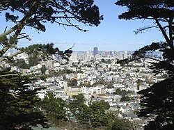
Noe Valley | |
|---|---|
 Noe Valley in 2013 | |
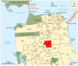
 Location within San Francisco | |
| Coordinates (24th St. & Noe St.): 37°45′05.2″N 122°25′54.7″W / 37.751444°N 122.431861°W | |
| Country | |
| State | |
| City-county | San Francisco |
| Government | |
| • Supervisor | Rafael Mandelman |
| • Assemblymember | Matt Haney (D)[1] |
| • State senator | Scott Wiener (D)[1] |
| • U. S. rep. | Nancy Pelosi (D)[2] |
| Area | |
• Total | 0.911 sq mi (2.36 km2) |
| • Land | 0.911 sq mi (2.36 km2) |
| Population (2019)[3] | |
• Total | 22,548 |
| • Density | 24,750/sq mi (9,560/km2) |
| Time zone | UTC-8 (Pacific) |
| • Summer (DST) | UTC-7 (PDT) |
| ZIP codes | 94110, 94114, 94131 |
| Area codes | 415/628 |
Noe Valley (/ˈnoʊ.i/ NOH-ee; originally spelt Noé) is a neighborhood in the central part of San Francisco, California. It is named for Don José de Jesús Noé, noted 19th-century Californio statesman and ranchero, who owned much of the area and served as mayor.
- ^ a b "Statewide Database". UC Regents. Archived from the original on February 1, 2015. Retrieved October 9, 2014.
- ^ "California's 11th Congressional District - Representatives & District Map". Civic Impulse, LLC.
- ^ a b "Noe Valley neighborhood in San Francisco, California (CA), 94110, 94114, 94131 subdivision profile - real estate, apartments, condos, homes, community, population, jobs, income, streets". city-data.com. Retrieved 24 January 2015.
