Nonantola | |
|---|---|
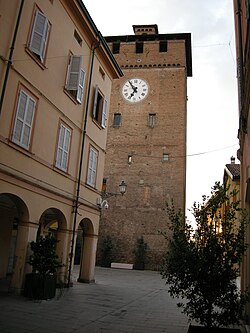
 Modenesi tower in town centre | |
| Coordinates: 44°40′41″N 11°02′32″E / 44.67806°N 11.04222°E | |
| Country | Italy |
| Region | Emilia-Romagna |
| Province | Modena (MO) |
| Frazioni | La Grande, Casette, Campazzo, Bagazzano, Rubbiara, Redù, Via Larga |
| Government | |
| • Mayor | Federica Nannetti |
| Area | |
| • Total | 55.32 km2 (21.36 sq mi) |
| Elevation | 20 m (70 ft) |
| Population (30 November 2017)[2] | |
| • Total | 15,921 |
| • Density | 290/km2 (750/sq mi) |
| Demonym | Nonantolani |
| Time zone | UTC+1 (CET) |
| • Summer (DST) | UTC+2 (CEST) |
| Postal code | 41015 |
| Dialing code | 059 |
| Patron saint | St. Sylvester |
| Saint day | December 31 |
| Website | Official website |
Nonantola (Modenese: Nunântla) is a town and comune in the province of Modena in the Emilia-Romagna region of northern Italy. It is in the Po Valley about 10 kilometres (6 mi) from Modena on the road to Ferrara.
- ^ "Superficie di Comuni Province e Regioni italiane al 9 ottobre 2011". Italian National Institute of Statistics. Retrieved 16 March 2019.
- ^ GeoDemo - Istat.it


