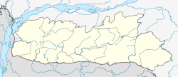
Nongpoh | |
|---|---|
Town | |
 Nongpoh town road | |
| Coordinates: 25°54′N 91°53′E / 25.9°N 91.88°E | |
| Country | |
| State | Meghalaya |
| District | Ri Bhoi |
| Elevation | 554 m (1,818 ft) |
| Population (2011)[1] | |
• Total | 17,055 |
| Language | |
| • Regional | Khasi[2] |
| Time zone | UTC+5:30 (IST) |
| Vehicle registration | ML-10 |
| Climate | Cwa |
Nongpoh (Khasi [nɒŋˈpɒ(ə)]) is the administrative centre of Ri-Bhoi district in the Indian state of Meghalaya. Nongpoh is located on National Highway 40, fifty-two kilometers from the state capital Shillong and forty-eight kilometers from Guwahati in the state of Assam.
- ^ Cite error: The named reference
Census2011Govwas invoked but never defined (see the help page). - ^ "52nd REPORT OF THE COMMISSIONER FOR LINGUISTIC MINORITIES IN INDIA" (PDF). nclm.nic.in. Ministry of Minority Affairs. Archived from the original (PDF) on 25 May 2017. Retrieved 30 March 2019.


