Noord Deurningen | |
|---|---|
village | |
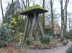
 Bell tower in Noord Deurningen | |
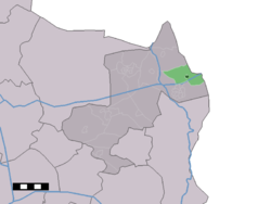
 The town centre (dark green) and the statistical district (light green) of Noord Deurningen in the municipality of Dinkelland. | |
| Coordinates: 52°23′49″N 7°1′31″E / 52.39694°N 7.02528°E | |
| Country | Netherlands |
| Province | Overijssel |
| Municipality | Dinkelland |
| Area | |
• Total | 11.03 km2 (4.26 sq mi) |
| Elevation | 19 m (62 ft) |
| Population | |
• Total | 1,070 |
| • Density | 97/km2 (250/sq mi) |
| Demonym | Noord-Deurningers |
| Time zone | UTC+1 (CET) |
| • Summer (DST) | UTC+2 (CEST) |
| Postal code | 7591[1] |
| Dialing code | 074 |
Noord Deurningen is a village in the Dutch province of Overijssel. It is a part of the municipality of Dinkelland, and lies about 11 km northeast of Oldenzaal.
- ^ a b c "Kerncijfers wijken en buurten 2021". Central Bureau of Statistics. Retrieved 15 March 2022.
- ^ "Postcodetool for 7591AA". Actueel Hoogtebestand Nederland (in Dutch). Het Waterschapshuis. Retrieved 15 March 2022.

