Nordreisa Municipality
Nordreisa kommune Ráissa suohkan Raisin komuuni | |
|---|---|
| Nordreisen herred (historic name) | |
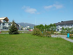
 View of Storslett | |
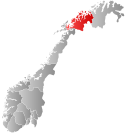
 Troms within Norway | |
 Nordreisa within Troms | |
| Coordinates: 69°42′18″N 21°12′33″E / 69.70500°N 21.20917°E | |
| Country | Norway |
| County | Troms |
| District | Nord-Troms |
| Established | 1 Jan 1886 |
| • Preceded by | Skjervøy Municipality |
| Administrative centre | Storslett |
| Government | |
| • Mayor (2019) | Hilde Anita Nyvoll (Ap) |
| Area | |
• Total | 3,437.77 km2 (1,327.33 sq mi) |
| • Land | 3,334.04 km2 (1,287.28 sq mi) |
| • Water | 103.73 km2 (40.05 sq mi) 3% |
| • Rank | #9 in Norway |
| Highest elevation | 1,360.59 m (4,463.88 ft) |
| Population (2024) | |
• Total | 4,794 |
| • Rank | #187 in Norway |
| • Density | 1.4/km2 (4/sq mi) |
| • Change (10 years) | |
| Demonym | Reisaværing[2] |
| Official language | |
| • Norwegian form | Bokmål |
| Time zone | UTC+01:00 (CET) |
| • Summer (DST) | UTC+02:00 (CEST) |
| ISO 3166 code | NO-5544[4] |
| Website | Official website |
Nordreisa (Norwegian), Ráisa (Northern Sami, pronounced [ˈraːjːsa]), or Raisi (Kven)[5][6][7] is a municipality in Troms county, Norway. The administrative centre of the municipality is the village of Storslett. Other villages include Oksfjordhamn, Sørkjosen, and Rotsund.
The municipality consists of the Reisadalen valley, with the river Reisaelva and deep pine forests, surrounded by mountains and high plateaus. Most people live in Storslett, where the river meets the Reisafjorden. Sørkjosen, just northwest of Storslett, is the location of Sørkjosen Airport with flights to Tromsø and several destinations in Finnmark. The European route E6 runs through the northern part of the municipality.
The 3,438-square-kilometre (1,327 sq mi) municipality is the 9th largest by area out of the 357 municipalities in Norway. Nordreisa is the 187th most populous municipality in Norway with a population of 4,794. The municipality's population density is 1.4 inhabitants per square kilometre (3.6/sq mi) and its population has decreased by 1.2% over the previous 10-year period.[8][9]
- ^ "Høgaste fjelltopp i kvar kommune" (in Norwegian). Kartverket. 16 January 2024.
- ^ "Navn på steder og personer: Innbyggjarnamn" (in Norwegian). Språkrådet.
- ^ "Forskrift om målvedtak i kommunar og fylkeskommunar" (in Norwegian). Lovdata.no.
- ^ Bolstad, Erik; Thorsnæs, Geir, eds. (26 January 2023). "Kommunenummer". Store norske leksikon (in Norwegian). Kunnskapsforlaget.
- ^ "Informasjon om stadnamn". Norgeskart (in Norwegian). Kartverket. Retrieved 7 July 2024.
- ^ "Fastsettelse av samisk og kvensk navn på Nordreisa kommune, Troms" (in Norwegian). Lovdata.no. 27 April 2018. Retrieved 13 July 2018.
- ^ "Saksprotokoll fra Nordreisa kommunestyre 26.10.17 - PS 52/17" (in Norwegian). Nordreisa kommune. 26 October 2017. Archived from the original on 28 November 2020. Retrieved 13 July 2018.
- ^ Statistisk sentralbyrå. "Table: 06913: Population 1 January and population changes during the calendar year (M)" (in Norwegian).
- ^ Statistisk sentralbyrå. "09280: Area of land and fresh water (km²) (M)" (in Norwegian).

