This article needs to be updated. (April 2022) |
North Andhra
Uttara Āndhra, Kaḷiṅga Āndhra | |
|---|---|
Clockwise from top: Kailasagiri hill top view, Arasavalli Sun Temple, Ganta stambham, Araku Valley, Kamalingeswara Temple, Bojjannakonda and INS Kursura museum. | |
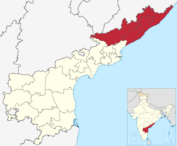
 Uttarandhra region with districts | |
| Country | |
| State | |
| Districts | |
| Largest cities | |
| Area | |
| • Total | 23,537 km2 (9,088 sq mi) |
| Population (2011) | |
| • Total | 9,338,177 |
| Languages | |
| • Official | Telugu |
| • Local | Kui · Odia · Koya · Sora · Kuvi |
| Time zone | UTC+05:30 (IST) |
| Vehicle registration | AP 30, AP 31, AP 32, AP 33, AP 34, AP 35, AP 39,AP40 |
| Largest airport | Visakhapatnam Airport |


North Andhra or Uttara Andhra (IAST: Uttara Āndhra), also known as Kalinga Andhra (IAST: Kaḷiṅga Āndhra),[1][2] is a geographic region in the Indian state of Andhra Pradesh. It is between the Eastern Ghats and the coast of the Bay of Bengal. It comprises six northern districts of the state, Srikakulam, Parvathipuram Manyam, Vizianagaram, Visakhapatnam, Alluri Sitharama Raju and Anakapalli.[3] As of 2011 census of India, the region with six districts has a population of 9,338,177.[4]
The region is in the extreme Northeast of Indian state of Andhra Pradesh. The region is skirted to a distance by Kandivalasagedda, Vamshadhara and Bahuda at certain stretches of their courses white a line of heights of the great Eastern Ghats run from Northeast. Kakinada and East Godavari Districts flanks in the southwest while Odisha bounds it on the north and Bay of Bengal on the South and the East and Parts of Telangana and Chattisgarh on the west. Visakhapatnam is the largest city of the region in terms of population and area.
Uttarandhra region is a part of Coastal Andhra region.
- ^ Chalam, K. S. (24 November 2016). Social Economy of Development in India. SAGE Publications India. p. 165. ISBN 9789385985126.
- ^ Subrahmanyam, Velcheti (20 October 2016). "Indefatigable talent". The Hindu. ISSN 0971-751X. Retrieved 6 June 2019.
- ^ "Uttarandhra in a State of Plenty, Penury". The New Indian Express. Archived from the original on 4 June 2014. Retrieved 8 May 2016.
- ^ "Statistical Abstract Andhra Pradesh, 2018" (PDF). CORE Dashboard. Gollapudi, Vijayawada: Directorate of Economics and Statistics, Government of Andhra Pradesh. p. 10. Retrieved 6 June 2019.


