North Eagle Butte, South Dakota | |
|---|---|
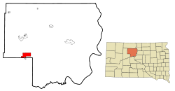
 Location in Dewey County and the state of South Dakota | |
| Coordinates: 45°00′57″N 101°15′39″W / 45.01583°N 101.26083°W | |
| Country | United States |
| State | South Dakota |
| County | Dewey |
| Area | |
| • Total | 8.83 sq mi (22.86 km2) |
| • Land | 8.82 sq mi (22.83 km2) |
| • Water | 0.01 sq mi (0.03 km2) |
| Elevation | 2,389 ft (728 m) |
| Population | |
| • Total | 1,879 |
| • Density | 213.11/sq mi (82.29/km2) |
| Time zone | UTC−7 (Mountain (MST)) |
| • Summer (DST) | UTC−6 (MDT) |
| Area code | 605 |
| FIPS code | 46-45548[4] |
| GNIS feature ID | 2393151[2] |
North Eagle Butte is a census-designated place (CDP) in Dewey County, South Dakota, United States, along the 45th parallel. The population was 1,879 at the 2020 census.[5]
- ^ "ArcGIS REST Services Directory". United States Census Bureau. Retrieved October 15, 2022.
- ^ a b U.S. Geological Survey Geographic Names Information System: North Eagle Butte, South Dakota
- ^ Cite error: The named reference
USCensusDecennial2020CenPopScriptOnlywas invoked but never defined (see the help page). - ^ "U.S. Census website". United States Census Bureau. Retrieved January 31, 2008.
- ^ "U.S. Census Bureau: North Eagle Butte CDP, South Dakota". www.census.gov. United States Census Bureau. Retrieved February 13, 2022.